
Theme: Later prehistoric Europe
The later prehistoric period within Europe, and particularly around the Atlantic façade, marks the widespread construction of large, evidently communal, structures built predominantly of earth, timber and/or stone. The vestiges of many earthworks and stone monuments dating to this period remain conspicuous in today’s landscape. People have long identified tangible connections with the sky at such monuments, mostly in the form of alignments upon the rising and setting points of particular celestial objects, such as the sun at the summer or winter solstice. Such alignments remain the focus of much attention among both professional archaeoastronomers and enthusiastic amateurs.
In dealing with such alignments one must take account of three fundamental issues. First, every oriented structure must point somewhere, whether intentionally or not. Second, several different factors might have influenced a structural orientation, of which only a few are related to the sky. Third, there are many potential astronomical targets, some of which may have shifted significantly within the chronological timeframe that can be identified from the broader archaeological evidence. There is, therefore, a strong likelihood of being able to fit a fortuitous astronomical alignment to almost any structural orientation, which is increased still further if one is prepared to choose the ‘best fit’ date.
One way to establish the intentionality of an alignment and to sustain a plausible astronomical explanation is to identify repeated trends. Fortunately, among European later prehistoric monuments there exist several geographically and chronologically well-defined clusters of architecturally similar constructions where systematic analyses can be, and have been, undertaken. A prerequisite is that the type of monument in question should have a clearly identifiable ‘principal axis’ or other major structural orientation whose importance can be convincingly argued on a priori grounds.
Even where an astronomical connection can be reliably established through its repetition among a group of monuments, one still needs to consider the broader archaeological context in order to interpret its cultural significance: why it was constructed, how it functioned and what social purposes it may have served. It is clear, for example, that burial tombs, even if astronomically oriented, were not ‘observatories’ if that is taken to mean that they were constructed primarily to facilitate astronomical observations. Instead, we should view the astronomical connection encapsulated in the monument as a tangible reflection of a connection existing in people’s minds between ancestors and/or ancestral spirits and the astronomical body in question. Its significance to us rests largely in revealing that connection. Similarly, astronomical alignments encapsulated in other types of monument such as enclosures and free-standing ‘temples’, even if periodically confirmed by observation, should be seen as secondary, albeit important and perhaps vital, aspects of the symbolism of those structures, whose interpretation inevitably leads to the consideration of issues such as ideology and cosmology.
Despite their continued predominance in discussions on the topic, tangible manifestations of astronomy in later prehistoric Europe are not confined to monumental alignments upon the horizon rising and setting points of celestial bodies. Other aspects of spatial patterning in the material record, as well as consideration of the situation of monuments within the landscape and human movement and experience in relation to the monuments, have become increasingly important in recent years.
Geographical and chronological context
In Europe, the term ‘later prehistory’ broadly refers to the period from the first appearance of farming communities (i.e. those who practised cultivation and/or animal husbandry) and lasted until the emergence of the classical civilizations and the Roman Empire. This covers the periods conventionally referred to as the Neolithic, Copper Age/Chalcolithic/Eneolithic, Bronze Age and Iron Age. The chronology varies from region to region: it stretches back as far as the 7th millennium BC in south-east Europe, as shown by the existence of numerous ‘tells’—mounds containing the remains of fixed settlements lasting for many generations—and lasts into the early centuries AD in places like Ireland and northern Europe where there was no Roman conquest.
The monuments that survive to characterise this period so prominently in today’s landscape include
- burial structures, typically stone chambers and passages covered, or once covered, in large earthen mounds;
- round enclosures or constructions, such as ‘henges’ and other circular earthworks, and stone circles;
- linear constructions, such as the earthen ‘cursus monuments’ concentrated in southern England, and the huge stone rows at Carnac in Brittany, France.
The main concentrations of these are around the Atlantic seaboard of western Europe, but they are also found in parts of central Europe, the Caucasus and the Russian steppes. Some, such as chambered tombs, were clearly places for the dead but may also have served a variety of functions for the living. The various purposes of others such as earthen enclosures, linear earthworks, stone circles and stone rows are much debated but they remain widely characterised as ‘ceremonial’ and/or ‘ritual’ monuments*.
Excavations have shown that many such monuments were altered and remodelled over time, Stonehenge (United Kingdom) being a famous example; another is the gradual ‘closure’ of various Scottish stone circles and their re-use as focal points for later burials. In other cases, constructions were destroyed and their component materials used for building new monuments. This is evident, for example, in Brittany (France), in the reuse of two adjacent pieces of a large menhir, presumably once standing, as the capstones in two large tombs (La Table des Marchand and Gavrinis) some 4 km apart.
* A variety of local terms is used to refer to such monuments: for example, single-chamber megalithic tombs with large capstones are known variously as dolmens, quoits, cromlechs, antas, and Hunebedden; earthen mounds as barrows, tumuli, and kurgans; and standing stones themselves as megaliths, menhirs, and orthostats.
Regional groupings of monuments
Fortunately, there exist many regional groupings of relatively modest monuments with evident similarities in construction technique and design, and presumably purpose, that can be shown, or can reasonably be assumed, to have been constructed within a relatively short period of time. The common characteristics of such monuments often include aspects of their landscape situation. Many types of monument also manifest a clear directionality, such as (in an enclosed structure such as a tomb) the direction faced by the entrance or (in the case of a standing monument) an axis of symmetry running through a distinctive feature such as the ‘recumbent’ stone (a stone set on its side rather than upright) found in certain Scottish and Irish stone circles. These principal directions are typically confined to an arc of about 120° (i.e. one third of all possible directions) or less, demonstrating beyond doubt that orientation was a factor of considerable importance to the builders. The range of directions concerned—the orientation ‘signature’, varies from group to group, along with other aspects of monument design.
Many different factors can influence a structural orientation, including constraints of the local topography (e.g., the earthen long barrows of Cranborne Chase in Dorset, southern England, whose predominantly south-easterly orientation apparently results from the long axes being preferentially oriented along natural ridges), terrestrial ‘targets’ such as other tombs (as is quite common among Neolithic passage tombs in Ireland), or prominent landscape features; even, simply, the direction of the prevailing wind. However, in most cases— given a scatter of monuments over an area with significant topographic variability—such consistency could only have been achieved by reference to the north-south line defined by the diurnal motion of the heavens. This provides the most crude, but also the most fundamental, evidence for an astronomical connection among a wide range of later prehistoric monuments in Europe.
Systematic surveys of over 3000 tombs and ‘temples’ in western Europe, from France to the Mediterranean, provide the first refinement of this evidence. Virtually no monuments face the northerly quadrant, where heavenly bodies such as the sun, moon and planets are never seen. The remaining directions can be split into four arcs: the solar rising (SR) arc to the east, corresponding to the part of the horizon where the sun rises at some time in the year; the ‘sun climbing’ (SC) arc to the SSE, corresponding to those directions where the sun is seen to climb in the sky as it passes across; the ‘sun descending’ (SD) arc to the SSW, and the sun setting (SS) arc to the west. The orientation signatures of local monument groups typically correspond to two of these arcs, namely SR/SC, SC/SD, or SD/SS. This supports the idea that the principal association was with the sun, although such conclusions are critically dependent upon the outlying orientations in the sample. Others argue for a lunar association, but this is more difficult to prove owing to the greater complexity of the lunar motions. The seven-stone antas of central Portugal and central-western Spain are of particular importance in that their orientations lie exclusively in the SR range.
A number of groups of British and Irish monuments have been studied more closely. While many of these have orientation signatures broadly similar to those just mentioned, these studies have revealed more subtle differences. In particular, certain groups of monuments at more northerly latitudes, such as the ‘recumbent stone circles’ of the Grampian region of eastern Scotland, have a clear relationship with the moon. This is thought to relate to the fact that, at these latitudes, the moon on occasion passes low across the southern sky, at which times it is especially prominent. The orientation of the site (and especially, the positioning of the recumbent stone) apparently related to observations of the full moon, and particularly its setting position, at midsummer. In other cases, such as the ‘axial stone circles’ of Counties Cork and Kerry in south-western Ireland, there is a clear orientation trend but no obvious association with any particular astronomical body.
Some of the most important groups of monuments with clear orientation trends are listed in Table 1.
Table 1. Some examples of groups of standing monuments whose principal orientations demonstrate an astronomical connection. In the lists of orientations and azimuths, outliers are excluded where they form less than 2% of the total. Key to references: R = Ruggles (1999); B = Burl (2000); H = Hoskin (2001); G = César González-García and Lourdes Costa-Ferrer, ’Orientations of the Dutch Hunebedden‘, Journal for the History of Astronomy 34 (2003), 219-226. * = The azimuths quoted are those of the chamber, which is different from that of the passage.
Type Date (M BC) Location Country No. of sites Orientations Azimuths (°) Astronomy Ref Short stone rows 3rd/2nd? Co. Cork, Co. Kerry Ireland 92 SSW/NNE-WSW/ENE 200/20-250/70 Moon? R Short stone rows 3rd/2nd? Western Scotland UK 44 SE/NW- SW/NE 120/300-230/50 Moon R Clava Cairns Early 2nd Invernessshire UK 28 S-SW 170-230 Moon R Recumbent stone circles Late 3rd Grampian region UK 97 SSE-SW 150-235 Moon B,R Earthen long barrows 4th Salisbury Plain UK 65 NE-S c. 50-180 Sun (SR/SC) R Hunebedden 4th/early 3rd Drenthe, Groningen Netherlands 76 NE-S* 50-170* Sun (SR/SC) G Bas-Rhône-type dolmens 3rd Provence, W Languedoc France 110 S-NW 170-300 Sun (SD/SS) H Languedoc-type dolmens 3rd East Languedoc France 103 SSE-NW 160-300 Sun (SD/SS) H All tombs 4th/3rd Iberia + W & cent. France Portugal, Spain, France 1576 NE-S 40-190 Sun (SR/SC) H All tombs 4th/3rd Iberia + Pyrenees Portugal, Spain, France 935 NE-S 60-190 Sun (SR/SC) H All tombs 4th/3rd West Iberia Portugal, Spain 324 ENE-ESE 60-140 Sun (SR) H Seven-stone antas 4th - late 3rd Alentejo; Extremadura Portugal, Spain 177 ENE-ESE 60-130 Sun (SR) H Taula sanctuaries Late 2nd - early 1st Menorca Spain 25 ESE -SSW 110- 210 S Cross & Centaurus H Tombe di giganti 3rd Northern Sardinia Italy 158 NE-S 50-190 Sun (SR/SC) H
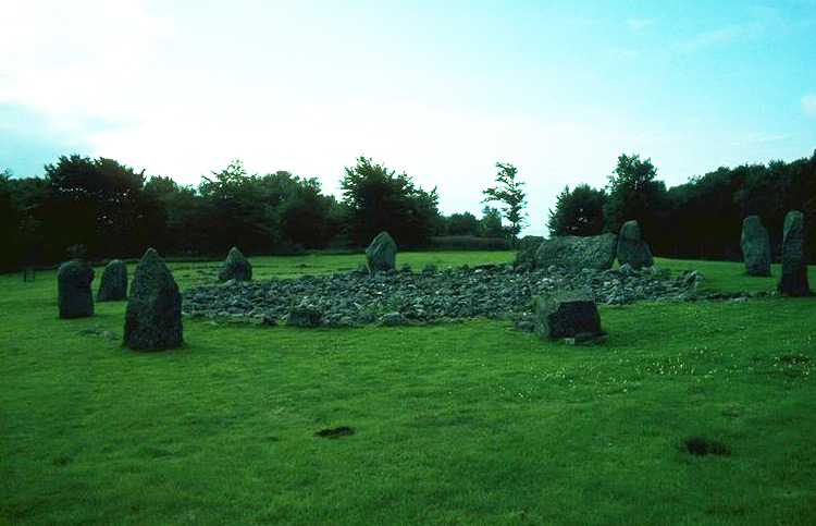
Fig. 1a. Loanhead of Daviot, Aberdeenshire, United Kingdom: one of 97 Scottish recumbent stone circles. Photograph © Clive Ruggles
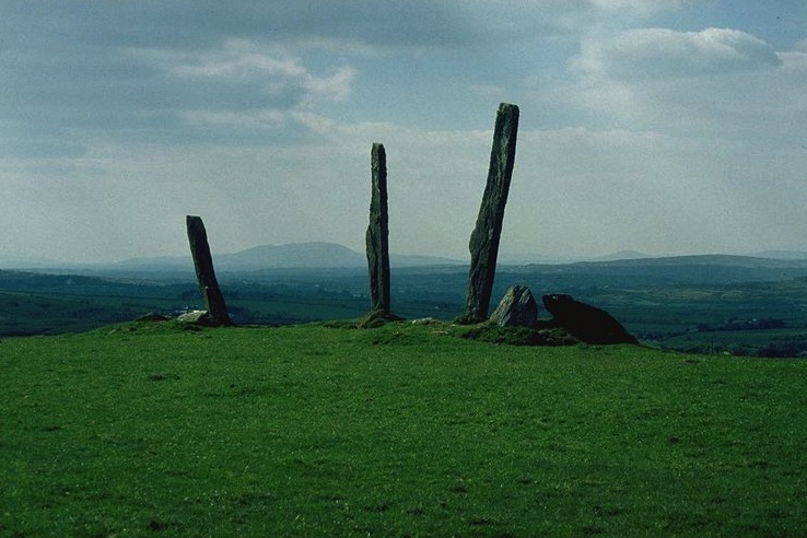
Fig. 1b. Gurranes, one of 92 short stone rows in south-west Ireland. Photograph © Clive Ruggles
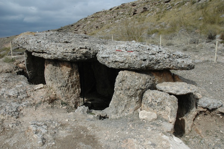
Fig. 1c. One of c. 200 oriented tombs at Río Gor, Granada, Spain. Photograph © Clive Ruggles
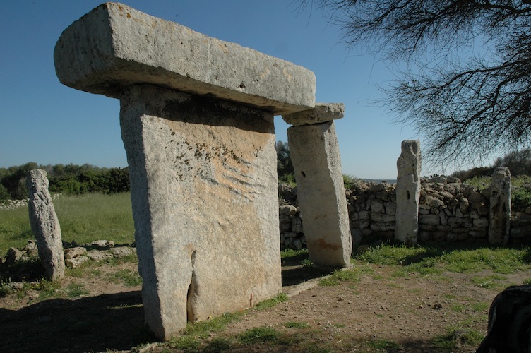
Fig. 1d. Talatí de Dalt, one of 25 taula sanctuaries in Menorca, Spain. Photograph © Clive Ruggles
Alignments in context
The later prehistoric period within Europe, and particularly around the Atlantic façade, marks the widespread construction of large, evidently communal, structures built predominantly of earth, timber and/or stone. The vestiges of many earthworks and stone monuments dating to this period remain conspicuous in today’s landscape. People have long identified tangible connections with the sky at such monuments, mostly in the form of alignments upon the rising and setting points of particular celestial objects, such as the sun at the summer or winter solstice. Such alignments remain the focus of much attention among both professional archaeoastronomers and enthusiastic amateurs.
In dealing with such alignments one must take account of three fundamental issues. First, every oriented structure must point somewhere, whether intentionally or not. Second, several different factors might have influenced a structural orientation, of which only a few are related to the sky. Third, there are many potential astronomical targets, some of which may have shifted significantly within the chronological timeframe that can be identified from the broader archaeological evidence. There is, therefore, a strong likelihood of being able to fit a fortuitous astronomical alignment to almost any structural orientation, which is increased still further if one is prepared to choose the ‘best fit’ date.
One way to establish the intentionality of an alignment and to sustain a plausible astronomical explanation is to identify repeated trends. Fortunately, among European later prehistoric monuments there exist several geographically and chronologically well-defined clusters of architecturally similar constructions where systematic analyses can be, and have been, undertaken. A prerequisite is that the type of monument in question should have a clearly identifiable ‘principal axis’ or other major structural orientation whose importance can be convincingly argued on a priori grounds.
Even where an astronomical connection can be reliably established through its repetition among a group of monuments, one still needs to consider the broader archaeological context in order to interpret its cultural significance: why it was constructed, how it functioned and what social purposes it may have served. It is clear, for example, that burial tombs, even if astronomically oriented, were not ‘observatories’ if that is taken to mean that they were constructed primarily to facilitate astronomical observations. Instead, we should view the astronomical connection encapsulated in the monument as a tangible reflection of a connection existing in people’s minds between ancestors and/or ancestral spirits and the astronomical body in question. Its significance to us rests largely in revealing that connection. Similarly, astronomical alignments encapsulated in other types of monument such as enclosures and free-standing ‘temples’, even if periodically confirmed by observation, should be seen as secondary, albeit important and perhaps vital, aspects of the symbolism of those structures, whose interpretation inevitably leads to the consideration of issues such as ideology and cosmology.
Despite their continued predominance in discussions on the topic, tangible manifestations of astronomy in later prehistoric Europe are not confined to monumental alignments upon the horizon rising and setting points of celestial bodies. Other aspects of spatial patterning in the material record, as well as consideration of the situation of monuments within the landscape and human movement and experience in relation to the monuments, have become increasingly important in recent years.
Geographical and chronological context
In Europe, the term ‘later prehistory’ broadly refers to the period from the first appearance of farming communities (i.e. those who practised cultivation and/or animal husbandry) and lasted until the emergence of the classical civilizations and the Roman Empire. This covers the periods conventionally referred to as the Neolithic, Copper Age/Chalcolithic/Eneolithic, Bronze Age and Iron Age. The chronology varies from region to region: it stretches back as far as the 7th millennium BC in south-east Europe, as shown by the existence of numerous ‘tells’—mounds containing the remains of fixed settlements lasting for many generations—and lasts into the early centuries AD in places like Ireland and northern Europe where there was no Roman conquest.
The monuments that survive to characterise this period so prominently in today’s landscape include
- burial structures, typically stone chambers and passages covered, or once covered, in large earthen mounds;
- round enclosures or constructions, such as ‘henges’ and other circular earthworks, and stone circles;
- linear constructions, such as the earthen ‘cursus monuments’ concentrated in southern England, and the huge stone rows at Carnac in Brittany, France.
The main concentrations of these are around the Atlantic seaboard of western Europe, but they are also found in parts of central Europe, the Caucasus and the Russian steppes. Some, such as chambered tombs, were clearly places for the dead but may also have served a variety of functions for the living. The various purposes of others such as earthen enclosures, linear earthworks, stone circles and stone rows are much debated but they remain widely characterised as ‘ceremonial’ and/or ‘ritual’ monuments*.
Excavations have shown that many such monuments were altered and remodelled over time, Stonehenge (United Kingdom) being a famous example; another is the gradual ‘closure’ of various Scottish stone circles and their re-use as focal points for later burials. In other cases, constructions were destroyed and their component materials used for building new monuments. This is evident, for example, in Brittany (France), in the reuse of two adjacent pieces of a large menhir, presumably once standing, as the capstones in two large tombs (La Table des Marchand and Gavrinis) some 4 km apart.
* A variety of local terms is used to refer to such monuments: for example, single-chamber megalithic tombs with large capstones are known variously as dolmens, quoits, cromlechs, antas, and Hunebedden; earthen mounds as barrows, tumuli, and kurgans; and standing stones themselves as megaliths, menhirs, and orthostats.
Regional groupings of monuments
Fortunately, there exist many regional groupings of relatively modest monuments with evident similarities in construction technique and design, and presumably purpose, that can be shown, or can reasonably be assumed, to have been constructed within a relatively short period of time. The common characteristics of such monuments often include aspects of their landscape situation. Many types of monument also manifest a clear directionality, such as (in an enclosed structure such as a tomb) the direction faced by the entrance or (in the case of a standing monument) an axis of symmetry running through a distinctive feature such as the ‘recumbent’ stone (a stone set on its side rather than upright) found in certain Scottish and Irish stone circles. These principal directions are typically confined to an arc of about 120° (i.e. one third of all possible directions) or less, demonstrating beyond doubt that orientation was a factor of considerable importance to the builders. The range of directions concerned—the orientation ‘signature’, varies from group to group, along with other aspects of monument design.
Many different factors can influence a structural orientation, including constraints of the local topography (e.g., the earthen long barrows of Cranborne Chase in Dorset, southern England, whose predominantly south-easterly orientation apparently results from the long axes being preferentially oriented along natural ridges), terrestrial ‘targets’ such as other tombs (as is quite common among Neolithic passage tombs in Ireland), or prominent landscape features; even, simply, the direction of the prevailing wind. However, in most cases— given a scatter of monuments over an area with significant topographic variability—such consistency could only have been achieved by reference to the north-south line defined by the diurnal motion of the heavens. This provides the most crude, but also the most fundamental, evidence for an astronomical connection among a wide range of later prehistoric monuments in Europe.
Systematic surveys of over 3000 tombs and ‘temples’ in western Europe, from France to the Mediterranean, provide the first refinement of this evidence. Virtually no monuments face the northerly quadrant, where heavenly bodies such as the sun, moon and planets are never seen. The remaining directions can be split into four arcs: the solar rising (SR) arc to the east, corresponding to the part of the horizon where the sun rises at some time in the year; the ‘sun climbing’ (SC) arc to the SSE, corresponding to those directions where the sun is seen to climb in the sky as it passes across; the ‘sun descending’ (SD) arc to the SSW, and the sun setting (SS) arc to the west. The orientation signatures of local monument groups typically correspond to two of these arcs, namely SR/SC, SC/SD, or SD/SS. This supports the idea that the principal association was with the sun, although such conclusions are critically dependent upon the outlying orientations in the sample. Others argue for a lunar association, but this is more difficult to prove owing to the greater complexity of the lunar motions. The seven-stone antas of central Portugal and central-western Spain are of particular importance in that their orientations lie exclusively in the SR range.
A number of groups of British and Irish monuments have been studied more closely. While many of these have orientation signatures broadly similar to those just mentioned, these studies have revealed more subtle differences. In particular, certain groups of monuments at more northerly latitudes, such as the ‘recumbent stone circles’ of the Grampian region of eastern Scotland, have a clear relationship with the moon. This is thought to relate to the fact that, at these latitudes, the moon on occasion passes low across the southern sky, at which times it is especially prominent. The orientation of the site (and especially, the positioning of the recumbent stone) apparently related to observations of the full moon, and particularly its setting position, at midsummer. In other cases, such as the ‘axial stone circles’ of Counties Cork and Kerry in south-western Ireland, there is a clear orientation trend but no obvious association with any particular astronomical body.
Some of the most important groups of monuments with clear orientation trends are listed in Table 1.
Table 1. Some examples of groups of standing monuments whose principal orientations demonstrate an astronomical connection. In the lists of orientations and azimuths, outliers are excluded where they form less than 2% of the total. Key to references: R = Ruggles (1999); B = Burl (2000); H = Hoskin (2001); G = César González-García and Lourdes Costa-Ferrer, ’Orientations of the Dutch Hunebedden‘, Journal for the History of Astronomy 34 (2003), 219-226. * = The azimuths quoted are those of the chamber, which is different from that of the passage.
Type Date (M BC) Location Country No. of sites Orientations Azimuths (°) Astronomy Ref Short stone rows 3rd/2nd? Co. Cork, Co. Kerry Ireland 92 SSW/NNE-WSW/ENE 200/20-250/70 Moon? R Short stone rows 3rd/2nd? Western Scotland UK 44 SE/NW- SW/NE 120/300-230/50 Moon R Clava Cairns Early 2nd Invernessshire UK 28 S-SW 170-230 Moon R Recumbent stone circles Late 3rd Grampian region UK 97 SSE-SW 150-235 Moon B,R Earthen long barrows 4th Salisbury Plain UK 65 NE-S c. 50-180 Sun (SR/SC) R Hunebedden 4th/early 3rd Drenthe, Groningen Netherlands 76 NE-S* 50-170* Sun (SR/SC) G Bas-Rhône-type dolmens 3rd Provence, W Languedoc France 110 S-NW 170-300 Sun (SD/SS) H Languedoc-type dolmens 3rd East Languedoc France 103 SSE-NW 160-300 Sun (SD/SS) H All tombs 4th/3rd Iberia + W & cent. France Portugal, Spain, France 1576 NE-S 40-190 Sun (SR/SC) H All tombs 4th/3rd Iberia + Pyrenees Portugal, Spain, France 935 NE-S 60-190 Sun (SR/SC) H All tombs 4th/3rd West Iberia Portugal, Spain 324 ENE-ESE 60-140 Sun (SR) H Seven-stone antas 4th - late 3rd Alentejo; Extremadura Portugal, Spain 177 ENE-ESE 60-130 Sun (SR) H Taula sanctuaries Late 2nd - early 1st Menorca Spain 25 ESE -SSW 110- 210 S Cross & Centaurus H Tombe di giganti 3rd Northern Sardinia Italy 158 NE-S 50-190 Sun (SR/SC) H
Fig. 1a. Loanhead of Daviot, Aberdeenshire, United Kingdom: one of 97 Scottish recumbent stone circles. Photograph © Clive Ruggles
Fig. 1b. Gurranes, one of 92 short stone rows in south-west Ireland. Photograph © Clive Ruggles
Fig. 1c. One of c. 200 oriented tombs at Río Gor, Granada, Spain. Photograph © Clive Ruggles
Fig. 1d. Talatí de Dalt, one of 25 taula sanctuaries in Menorca, Spain. Photograph © Clive Ruggles
Alignments in context
Fortunately, there exist many regional groupings of relatively modest monuments with evident similarities in construction technique and design, and presumably purpose, that can be shown, or can reasonably be assumed, to have been constructed within a relatively short period of time. The common characteristics of such monuments often include aspects of their landscape situation. Many types of monument also manifest a clear directionality, such as (in an enclosed structure such as a tomb) the direction faced by the entrance or (in the case of a standing monument) an axis of symmetry running through a distinctive feature such as the ‘recumbent’ stone (a stone set on its side rather than upright) found in certain Scottish and Irish stone circles. These principal directions are typically confined to an arc of about 120° (i.e. one third of all possible directions) or less, demonstrating beyond doubt that orientation was a factor of considerable importance to the builders. The range of directions concerned—the orientation ‘signature’, varies from group to group, along with other aspects of monument design.
Many different factors can influence a structural orientation, including constraints of the local topography (e.g., the earthen long barrows of Cranborne Chase in Dorset, southern England, whose predominantly south-easterly orientation apparently results from the long axes being preferentially oriented along natural ridges), terrestrial ‘targets’ such as other tombs (as is quite common among Neolithic passage tombs in Ireland), or prominent landscape features; even, simply, the direction of the prevailing wind. However, in most cases— given a scatter of monuments over an area with significant topographic variability—such consistency could only have been achieved by reference to the north-south line defined by the diurnal motion of the heavens. This provides the most crude, but also the most fundamental, evidence for an astronomical connection among a wide range of later prehistoric monuments in Europe.
Systematic surveys of over 3000 tombs and ‘temples’ in western Europe, from France to the Mediterranean, provide the first refinement of this evidence. Virtually no monuments face the northerly quadrant, where heavenly bodies such as the sun, moon and planets are never seen. The remaining directions can be split into four arcs: the solar rising (SR) arc to the east, corresponding to the part of the horizon where the sun rises at some time in the year; the ‘sun climbing’ (SC) arc to the SSE, corresponding to those directions where the sun is seen to climb in the sky as it passes across; the ‘sun descending’ (SD) arc to the SSW, and the sun setting (SS) arc to the west. The orientation signatures of local monument groups typically correspond to two of these arcs, namely SR/SC, SC/SD, or SD/SS. This supports the idea that the principal association was with the sun, although such conclusions are critically dependent upon the outlying orientations in the sample. Others argue for a lunar association, but this is more difficult to prove owing to the greater complexity of the lunar motions. The seven-stone antas of central Portugal and central-western Spain are of particular importance in that their orientations lie exclusively in the SR range.
A number of groups of British and Irish monuments have been studied more closely. While many of these have orientation signatures broadly similar to those just mentioned, these studies have revealed more subtle differences. In particular, certain groups of monuments at more northerly latitudes, such as the ‘recumbent stone circles’ of the Grampian region of eastern Scotland, have a clear relationship with the moon. This is thought to relate to the fact that, at these latitudes, the moon on occasion passes low across the southern sky, at which times it is especially prominent. The orientation of the site (and especially, the positioning of the recumbent stone) apparently related to observations of the full moon, and particularly its setting position, at midsummer. In other cases, such as the ‘axial stone circles’ of Counties Cork and Kerry in south-western Ireland, there is a clear orientation trend but no obvious association with any particular astronomical body.
Some of the most important groups of monuments with clear orientation trends are listed in Table 1.
Table 1. Some examples of groups of standing monuments whose principal orientations demonstrate an astronomical connection. In the lists of orientations and azimuths, outliers are excluded where they form less than 2% of the total. Key to references: R = Ruggles (1999); B = Burl (2000); H = Hoskin (2001); G = César González-García and Lourdes Costa-Ferrer, ’Orientations of the Dutch Hunebedden‘, Journal for the History of Astronomy 34 (2003), 219-226. * = The azimuths quoted are those of the chamber, which is different from that of the passage.
| Type | Date (M BC) | Location | Country | No. of sites | Orientations | Azimuths (°) | Astronomy | Ref |
|---|---|---|---|---|---|---|---|---|
| Short stone rows | 3rd/2nd? | Co. Cork, Co. Kerry | Ireland | 92 | SSW/NNE-WSW/ENE | 200/20-250/70 | Moon? | R |
| Short stone rows | 3rd/2nd? | Western Scotland | UK | 44 | SE/NW- SW/NE | 120/300-230/50 | Moon | R |
| Clava Cairns | Early 2nd | Invernessshire | UK | 28 | S-SW | 170-230 | Moon | R |
| Recumbent stone circles | Late 3rd | Grampian region | UK | 97 | SSE-SW | 150-235 | Moon | B,R |
| Earthen long barrows | 4th | Salisbury Plain | UK | 65 | NE-S | c. 50-180 | Sun (SR/SC) | R |
| Hunebedden | 4th/early 3rd | Drenthe, Groningen | Netherlands | 76 | NE-S* | 50-170* | Sun (SR/SC) | G |
| Bas-Rhône-type dolmens | 3rd | Provence, W Languedoc | France | 110 | S-NW | 170-300 | Sun (SD/SS) | H |
| Languedoc-type dolmens | 3rd | East Languedoc | France | 103 | SSE-NW | 160-300 | Sun (SD/SS) | H |
| All tombs | 4th/3rd | Iberia + W & cent. France | Portugal, Spain, France | 1576 | NE-S | 40-190 | Sun (SR/SC) | H |
| All tombs | 4th/3rd | Iberia + Pyrenees | Portugal, Spain, France | 935 | NE-S | 60-190 | Sun (SR/SC) | H |
| All tombs | 4th/3rd | West Iberia | Portugal, Spain | 324 | ENE-ESE | 60-140 | Sun (SR) | H |
| Seven-stone antas | 4th - late 3rd | Alentejo; Extremadura | Portugal, Spain | 177 | ENE-ESE | 60-130 | Sun (SR) | H |
| Taula sanctuaries | Late 2nd - early 1st | Menorca | Spain | 25 | ESE -SSW | 110- 210 | S Cross & Centaurus | H |
| Tombe di giganti | 3rd | Northern Sardinia | Italy | 158 | NE-S | 50-190 | Sun (SR/SC) | H |
Fig. 1a. Loanhead of Daviot, Aberdeenshire, United Kingdom: one of 97 Scottish recumbent stone circles. Photograph © Clive Ruggles
Fig. 1b. Gurranes, one of 92 short stone rows in south-west Ireland. Photograph © Clive Ruggles
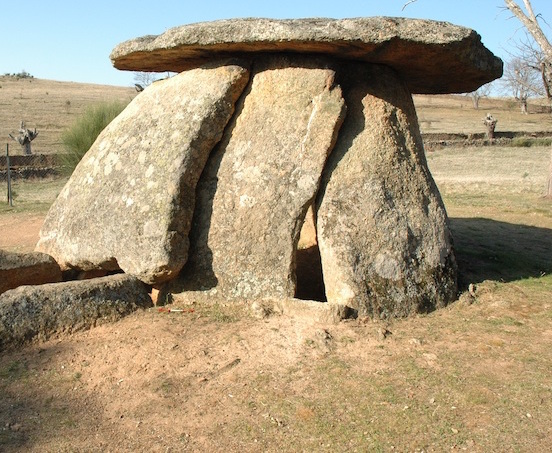
Fig. 1c. One of c. 200 oriented tombs at Río Gor, Granada, Spain. Photograph © Clive Ruggles
Fig. 1d. Talatí de Dalt, one of 25 taula sanctuaries in Menorca, Spain. Photograph © Clive Ruggles