

Category of Astronomical Heritage: tangible immovable
Stonehenge World Heritage Property, United Kingdom
Format: Short Description (ICOMOS-IAU Case Study format)
Presentation
Geographical position
County of Wiltshire, England, United Kingdom
Location
Latitude 51° 10′ 44″ N, longitude 1° 49′ 34″ E. Elevation 103m above mean sea level.
General description
The Stonehenge World Heritage Site (WHS), one half of the ’Stonehenge, Avebury and Associated Sites‘ WHS (no. 373) inscribed in 1986, comprises an area of 2,665 ha (26.6 km²) with Stonehenge stone circle approximately at its centre. Stonehenge is the most architecturally sophisticated prehistoric stone circle in the world and, in addition, the WHS around it contains many hundreds of archaeological sites and monuments, many of which are also prehistoric. These monuments and their associated landscapes help us to understand Neolithic and Bronze Age ceremonial and mortuary practices in England and indeed in north-west Europe. They demonstrate around 2,000 years of continuous use and monument building between c. 3700 and c. 1600 BC.
One of the most important features of Stonehenge is that it is aligned along the midwinter sunset-midsummer sunrise solstitial axis (approximately SW-NE). We now know that a number of other prehistoric sites in the Stonehenge WHS also have astronomical significance, with a number of monuments aligned along this same solstitial axis and others along the opposite midsummer sunset-midwinter sunrise solstitial axis (approximately NW-SE).
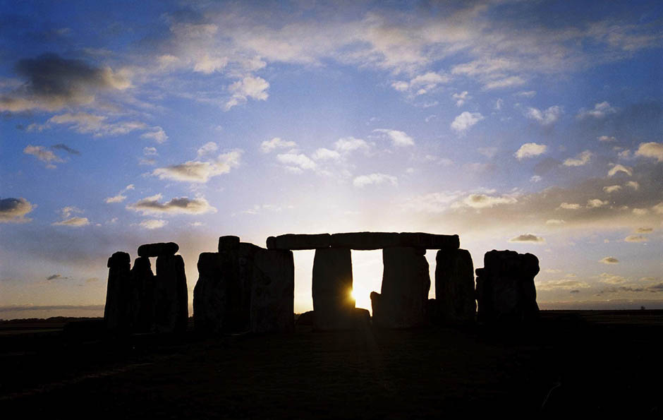
Fig. 1: The midwinter sunset at Stonehenge taken from the Stonehenge Avenue, and showing the solstitial axis through the monument.
Photograph by James O Davies, © English Heritage (Photo Library N030018).
Brief inventory
The Stonehenge WHS contains more than 700 archaeological features, including more than 350 burial mounds, and a number of key monuments such as the Cursus (c. 3600-3400 BC); Woodhenge (c. 2300 BC), Durrington Walls henge (c. 2500 BC) and the Stonehenge Avenue (c. 2500-1700 BC). A new henge has recently been discovered at West Amesbury (c. 2400 BC) at the end of the Stonehenge Avenue.
A number of these monuments appear to have been deliberately aligned along the midwinter sunset-midsummer sunrise solstitial axis: Stonehenge stone circle, the ‘final approach’ of the Stonehenge Avenue, Coneybury henge, and Woodhenge. By contrast, a number of other monuments appear to have been aligned along the midsummer sunset-midwinter sunrise solstitial axis, including the timber circle known as Durrington Walls 68 and possibly the timber Northern Circle at Durrington Walls. There are also two further definite examples on significantly sloping ground, thus permitting us to identify their directionality: these are the recently discovered Durrington Walls Avenue, which is aligned on the midsummer sunset, and the Durrington Walls Southern Circle (another timber circle), which is aligned on the midwinter sunrise.
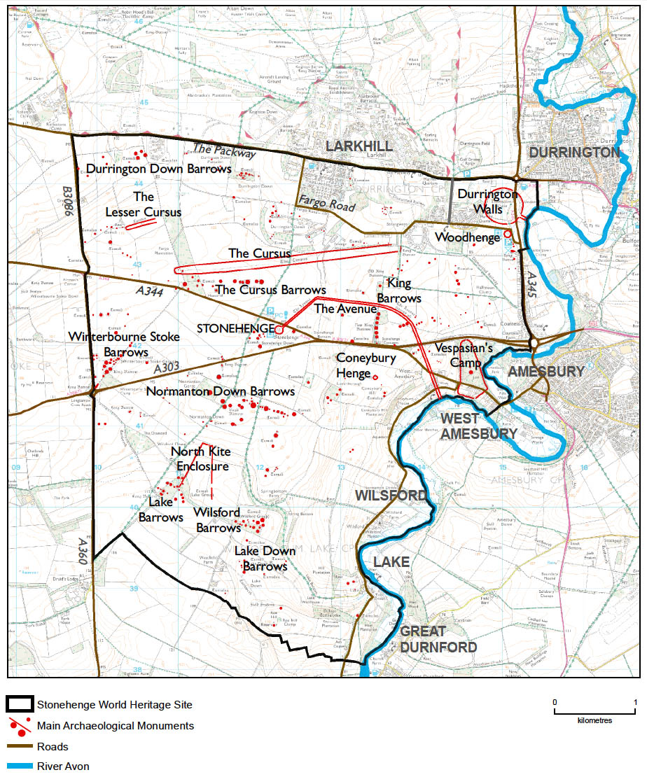
Fig. 2: Map of the Stonehenge World Heritage Site. Based on scheduled monument information from the English Heritage GIS
combined with features drawn from Ordnance Survey mapping data. © English Heritage.
History
County of Wiltshire, England, United Kingdom
Location
Latitude 51° 10′ 44″ N, longitude 1° 49′ 34″ E. Elevation 103m above mean sea level.
General description
The Stonehenge World Heritage Site (WHS), one half of the ’Stonehenge, Avebury and Associated Sites‘ WHS (no. 373) inscribed in 1986, comprises an area of 2,665 ha (26.6 km²) with Stonehenge stone circle approximately at its centre. Stonehenge is the most architecturally sophisticated prehistoric stone circle in the world and, in addition, the WHS around it contains many hundreds of archaeological sites and monuments, many of which are also prehistoric. These monuments and their associated landscapes help us to understand Neolithic and Bronze Age ceremonial and mortuary practices in England and indeed in north-west Europe. They demonstrate around 2,000 years of continuous use and monument building between c. 3700 and c. 1600 BC.
One of the most important features of Stonehenge is that it is aligned along the midwinter sunset-midsummer sunrise solstitial axis (approximately SW-NE). We now know that a number of other prehistoric sites in the Stonehenge WHS also have astronomical significance, with a number of monuments aligned along this same solstitial axis and others along the opposite midsummer sunset-midwinter sunrise solstitial axis (approximately NW-SE).
Fig. 1: The midwinter sunset at Stonehenge taken from the Stonehenge Avenue, and showing the solstitial axis through the monument.
Photograph by James O Davies, © English Heritage (Photo Library N030018).
Brief inventory
The Stonehenge WHS contains more than 700 archaeological features, including more than 350 burial mounds, and a number of key monuments such as the Cursus (c. 3600-3400 BC); Woodhenge (c. 2300 BC), Durrington Walls henge (c. 2500 BC) and the Stonehenge Avenue (c. 2500-1700 BC). A new henge has recently been discovered at West Amesbury (c. 2400 BC) at the end of the Stonehenge Avenue.
A number of these monuments appear to have been deliberately aligned along the midwinter sunset-midsummer sunrise solstitial axis: Stonehenge stone circle, the ‘final approach’ of the Stonehenge Avenue, Coneybury henge, and Woodhenge. By contrast, a number of other monuments appear to have been aligned along the midsummer sunset-midwinter sunrise solstitial axis, including the timber circle known as Durrington Walls 68 and possibly the timber Northern Circle at Durrington Walls. There are also two further definite examples on significantly sloping ground, thus permitting us to identify their directionality: these are the recently discovered Durrington Walls Avenue, which is aligned on the midsummer sunset, and the Durrington Walls Southern Circle (another timber circle), which is aligned on the midwinter sunrise.
Fig. 2: Map of the Stonehenge World Heritage Site. Based on scheduled monument information from the English Heritage GIS
combined with features drawn from Ordnance Survey mapping data. © English Heritage.
History
The Stonehenge World Heritage Site (WHS), one half of the ’Stonehenge, Avebury and Associated Sites‘ WHS (no. 373) inscribed in 1986, comprises an area of 2,665 ha (26.6 km²) with Stonehenge stone circle approximately at its centre. Stonehenge is the most architecturally sophisticated prehistoric stone circle in the world and, in addition, the WHS around it contains many hundreds of archaeological sites and monuments, many of which are also prehistoric. These monuments and their associated landscapes help us to understand Neolithic and Bronze Age ceremonial and mortuary practices in England and indeed in north-west Europe. They demonstrate around 2,000 years of continuous use and monument building between c. 3700 and c. 1600 BC.
One of the most important features of Stonehenge is that it is aligned along the midwinter sunset-midsummer sunrise solstitial axis (approximately SW-NE). We now know that a number of other prehistoric sites in the Stonehenge WHS also have astronomical significance, with a number of monuments aligned along this same solstitial axis and others along the opposite midsummer sunset-midwinter sunrise solstitial axis (approximately NW-SE).
Photograph by James O Davies, © English Heritage (Photo Library N030018).
Brief inventory
The Stonehenge WHS contains more than 700 archaeological features, including more than 350 burial mounds, and a number of key monuments such as the Cursus (c. 3600-3400 BC); Woodhenge (c. 2300 BC), Durrington Walls henge (c. 2500 BC) and the Stonehenge Avenue (c. 2500-1700 BC). A new henge has recently been discovered at West Amesbury (c. 2400 BC) at the end of the Stonehenge Avenue.
A number of these monuments appear to have been deliberately aligned along the midwinter sunset-midsummer sunrise solstitial axis: Stonehenge stone circle, the ‘final approach’ of the Stonehenge Avenue, Coneybury henge, and Woodhenge. By contrast, a number of other monuments appear to have been aligned along the midsummer sunset-midwinter sunrise solstitial axis, including the timber circle known as Durrington Walls 68 and possibly the timber Northern Circle at Durrington Walls. There are also two further definite examples on significantly sloping ground, thus permitting us to identify their directionality: these are the recently discovered Durrington Walls Avenue, which is aligned on the midsummer sunset, and the Durrington Walls Southern Circle (another timber circle), which is aligned on the midwinter sunrise.
Fig. 2: Map of the Stonehenge World Heritage Site. Based on scheduled monument information from the English Heritage GIS
combined with features drawn from Ordnance Survey mapping data. © English Heritage.
History
The Stonehenge WHS contains more than 700 archaeological features, including more than 350 burial mounds, and a number of key monuments such as the Cursus (c. 3600-3400 BC); Woodhenge (c. 2300 BC), Durrington Walls henge (c. 2500 BC) and the Stonehenge Avenue (c. 2500-1700 BC). A new henge has recently been discovered at West Amesbury (c. 2400 BC) at the end of the Stonehenge Avenue.
A number of these monuments appear to have been deliberately aligned along the midwinter sunset-midsummer sunrise solstitial axis: Stonehenge stone circle, the ‘final approach’ of the Stonehenge Avenue, Coneybury henge, and Woodhenge. By contrast, a number of other monuments appear to have been aligned along the midsummer sunset-midwinter sunrise solstitial axis, including the timber circle known as Durrington Walls 68 and possibly the timber Northern Circle at Durrington Walls. There are also two further definite examples on significantly sloping ground, thus permitting us to identify their directionality: these are the recently discovered Durrington Walls Avenue, which is aligned on the midsummer sunset, and the Durrington Walls Southern Circle (another timber circle), which is aligned on the midwinter sunrise.
combined with features drawn from Ordnance Survey mapping data. © English Heritage.