

Category of Astronomical Heritage: tangible immovable
Stonehenge World Heritage Property, United Kingdom
Format: Full Description (IAU Extended Case Study format)
Identification of the property
Country/State Party
England, United Kingdom
State/Province/Region
County of Wiltshire
Name
Stonehenge, Avebury and Associated Sites
Geographical co-ordinates and/or UTM
Monument NGR Latitude Longitude Elevation Stonehenge SU 1225 4219 51° 10′ 44″ N 1° 49′ 34″ W 102 m Woodhenge SU 1505 4338 51° 11′ 22″ N 1° 47′ 10″ W 98 m Southern Circle, Durrington Walls SU 1514 4366 51° 11′ 31″ N 1° 47′ 05″ W 88 m
Maps and plans,
showing boundaries of property and buffer zone
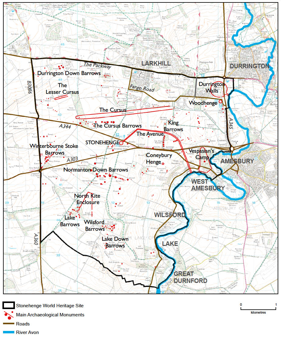
Fig. 1. Map of the Stonehenge World Heritage Site. Based on scheduled monument information from the English Heritage GIS combined with features drawn from Ordnance Survey mapping data. © Historic England
The current boundary is as shown in Map 1 in the Stonehenge WHS Management Plan 2009 (Young, Chadburn and Bedu 2009: 175) (see Fig. 1). There is no buffer zone, but the current Stonehenge WHS Committee considers that a setting study should be carried out (Simmonds and Thomas 2015: Policy 2b/ Action 15). Earlier policies had considered that a buffer zone was not needed if current government guidance was followed (National Planning Policy Framework, 2012; Circular 07/2009 on The Protection of World Heritage Sites; The Protection & Management of World Heritage Sites in England, English Heritage Guidance Note to Circular for England on the Protection of World Heritage Sites 2009).
A minor boundary review is currently under way (2015), being one of the actions recommended in the 2009 Stonehenge Management Plan (Young, Chadburn and Bedu 2009: 120).
The Avebury part of the World Heritage Property is not considered further here, as there is no secure evidence for astronomical importance, other than the general one which is noted in southern Britain, that most of its long barrows are roughly aligned towards the sun-climbing or sun-rising parts of the sky (Ruggles 2012).
Area of property and buffer zone
Stonehenge World Heritage Property (WHP) currently comprises an area of 2,665 hectares (26.6 km2) of land with Stonehenge at its approximate centre. There is no buffer zone.
Description
Description of the property
Stonehenge WHP forms one half of the Stonehenge, Avebury and Associated Sites WHP, which is internationally important for its complexes of outstanding prehistoric funerary and ceremonial monuments of the Neolithic and Early Bronze Age. Stonehenge is the most architecturally sophisticated prehistoric stone circle in the world and, in addition, the WHP around it contains many hundreds of archaeological sites and monuments, many of which are prehistoric too. These monuments in their associated landscapes help us to understand Neolithic and Bronze Age ceremonial and mortuary practices in England and indeed in north-west Europe. They demonstrate around 2000 years of continuous use and monument building between c. 3700 BC and 1600 BC.
One of the most important features of Stonehenge – one that has been recognised since the 18th century when it was noted by the antiquarian William Stukeley – is that its principal axis of symmetry is aligned upon winter solstice (“midwinter”) sunset in one direction and summer solstice (“midsummer”) sunrise in the other. We now know that a number of other prehistoric sites in the Stonehenge WHP also have astronomical significance, with some monuments oriented towards midwinter sunset and/or midsummer sunrise and others towards midsummer sunset or midwinter sunrise (Ruggles 2006; 2014). This contrasts with Avebury, where there are no known sites that convincingly demonstrate deliberate alignment in any of the solstitial directions.
See also the official brief description of the property that was agreed by UNESCO in July 2008 (quoted in Young, Chadburn and Bedu 2009: 21, section 3.2). A more detailed description of the Stonehenge WHP is set out in Appendix G (ibid.).
Six monuments in the Stonehenge WHP are considered to have significant astronomical alignments:
- Stone settings at Stonehenge (Bluestone horseshoe, Trilithon horseshoe, Bluestone Circle, Sarsen Circle, Slaughter Stone and its companion, Heel Stone and its companion)
- Stonehenge Avenue (straight segment closest to Stonehenge)
- Woodhenge (timber circles rings C–F and grave)
- Southern Circle, Durrington Walls
- Southern Circle Avenue, Durrington Walls
- Stonehenge Station-Stone rectangle
More details on these sites and alignments can be found in the section below and in Table 1.
Table 1: Summary of significant astronomical alignments in the Stonehenge WHP, with reference to the sites and components that might carry the OUV of the WHP in relation to astronomy.
Attribute of OUV Component Likely alignment Likely date of
construction 4. The design of Neolithic and Bronze Age funerary and ceremonial sites and monuments in relation to the skies and astronomy Stone settings at Stonehenge (Bluestone and Trilithon horseshoes, Bluestone Circle, Sarsen Circle, Slaughter Stone and its companion, Heel Stone and its companion), and the relevant sightlines and horizons Midwinter sunset (but could also be midsummer sunrise) c. 2500 BC Stonehenge Avenue (straight segment closest to Stonehenge) and the relevant sightlines and horizons Midwinter sunset (but could also be midsummer sunrise) c. 2300 BC Woodhenge and the relevant sightlines and horizons Midwinter sunset (but could also be midsummer sunrise) c. 2500 BC Southern Circle, Durrington Walls and the relevant sightline and horizon Midwinter sunrise c. 2500 BC Southern Circle Avenue, Durrington Walls and the relevant sightline and horizon Midsummer sunset c. 2500 BC Stonehenge Station-Stone rectangle and the relevant sightlines and horizons Most southerly moonrise/ most northerly moonset and Midsummer sunrise/ midwinter sunset c. 2500 BC
History and development
The first ’monument‘ at Stonehenge WHP comprised an alignment of three Mesolithic pits (c. 8,000 BC) located just to the north-west of Stonehenge monument, which apparently contained huge timber posts. But the area became more intensively used from the early and middle Neolithic onwards (c. 4,000-3,000 BC), with the construction of a number of funerary and ceremonial monuments such as Neolithic long barrows (communal burial mounds) and a causewayed enclosure known as Robin Hood’s Ball. Two long earthwork enclosures known as Cursuses - the Greater and Lesser - were also built towards the end of this period.
The lengthy history of Stonehenge itself started around 3,000 BC with the construction of a circular enclosure formed by a bank and ditch, containing the 56 pits known as the Aubrey Holes. Later, stones were added to the monument c. 2,500 BC, culminating in the construction of the stone circle, the remains of which we see today.
This stone-circle phase of the monument is the one that has the most readily apparent astronomical importance, with the axis of symmetry through the Bluestone and Trilithon horseshoes, between the Slaughter Stone and its companion, and between the Heel Stone and its companion, being aligned towards midwinter sunset in one direction and midsummer sunrise in the other (Ruggles 2006). Additionally, it is clear that the Sarsen Circle and Bluestone Circle are not completely regular, and were arranged and worked to respect the solstitial alignment, particularly the midwinter sunset alignment (Abbott and Anderson-Whymark 2012; 18, 20-22, 25, 50-53). It may also have been significant that the rectangle of four Station Stones just outside the bank and ditch, which may pre-date the Sarsen Circle, is broadly aligned lengthways upon the most southerly possible rising position and the most northerly setting position of the moon, as well as following the main solstitial axis across its width in the perpendicular direction (Ruggles 1997: 219-220). It is interesting and almost certainly not a coincidence that the width of the Station-Stone rectangle just exceeds the diameter of the Sarsen Circle, so it is possible that these lunar alignments could have been viewed even with the Sarsen Circle in place (Ruggles 2014: 1235).
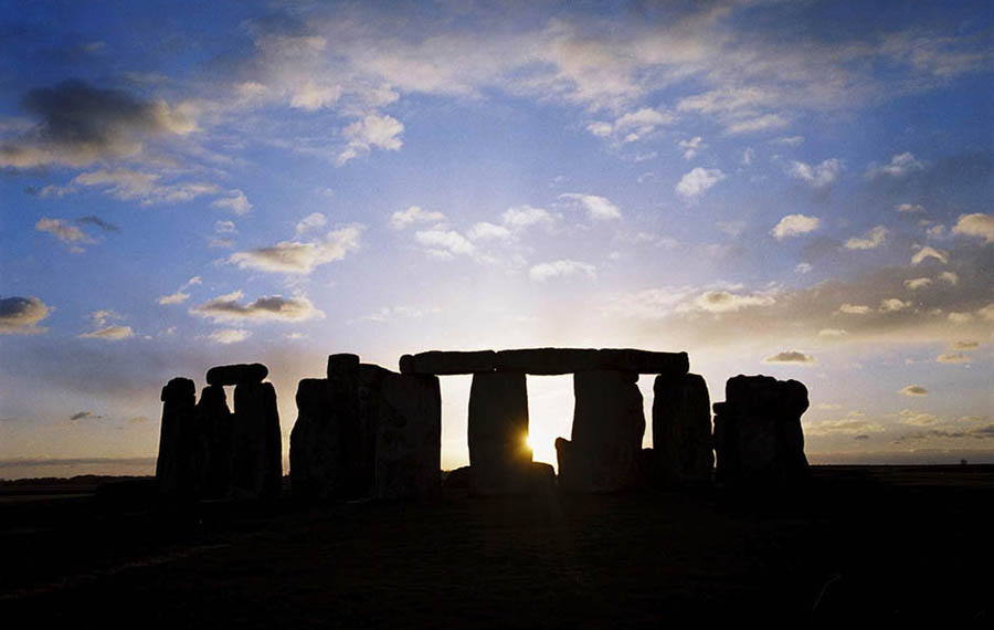
Fig. 2. The midwinter sunset at Stonehenge taken from the Stonehenge Avenue, and showing the setting winter solstice sun seen through the monument. Photograph by James O. Davies, © Historic England (Photo Library N030018)

Fig. 3. The Stonehenge Avenue is aligned on the solstitial axis. In places, periglacial stripes appear to run parallel with it—one stripe is apparently visible as a shallow linear depression just to the left of the Avenue on this photograph. © 1994 Crown Copyright, Historic England NMR 15041_26
The builders dragged stones for Stonehenge weighing up to 40 tonnes, from distances up to 240km away. They engineered the monument exactly so that the midwinter sun set between the two largest stones (the great trilithon and its fallen companion), and probably between the Heel Stone and its now-lost companion, and the Slaughter Stone and its lost companion, if one were viewing this sunset from the Avenue (Fig. 2). The midsummer sunrise may also have been important to the original builders. Standing with their backs to the largest trilithon, and looking down the Stonehenge Avenue, they could have seen the sun rise over the horizon to the north-east. Although the summer solstice is the main focus for modern celebrations, most scholars consider it much more likely that the stones were originally used mainly at midwinter (Fernie 1994: 155-156). This view has recently been strengthened by the results of a laser-scan at Stonehenge commissioned by English Heritage in 2011 and a subsequent archaeological analysis of the results in 2012. These have revealed that much more care was taken in dressing the stones that would be visible when approaching the monument from its Avenue: the stones in the Sarsen Circle at this point were all completely pick-dressed to remove the uneven surface. By contrast, the stones at the very ’back‘ of the monument (for example, the outer faces of the sarsen stones on the south-west side of the circle) were not dressed or shaped with the same care and attention (Abbott and Anderson-Whymark 2012).
Part of the Stonehenge Avenue (c. 2,300 BC) itself is aligned along the main ’solstitial axis‘ of Stonehenge (Fig. 3), and this part is still visible as an earthwork (Fig. 4). Excavations and recent geophysical surveys along its length have revealed buried linear geological features known as periglacial stripes, which might have been visible above ground during prehistory, for example through differential vegetation growth. In places, some of these stripes appear to be aligned on the solstitial axis, and the Avenue may have been built to formalise this natural phenomenon: this may be one of the reasons why the area was special to prehistoric peoples (Parker Pearson 2012: 240-248; Ruggles 2014: 1234).
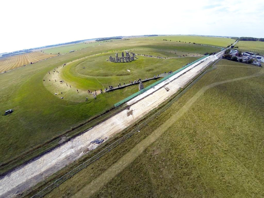
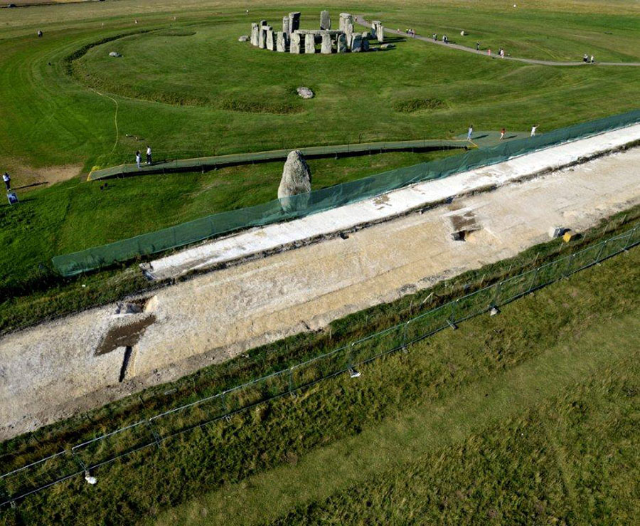
Fig. 4. Two views of the Stonehenge Avenue ditches under excavation, August 2013. Photographs by Adam Stanford, Aerial-Cam. © English Heritage
Also built during this period around 2,500-2,300 BC were a number of other monuments, including Durrington Walls henge and Woodhenge, which also appear to contain solstitial alignments. Woodhenge is interesting because the solstitial alignment is manifested in the oval shape of its concentric timber rings, rather than the position of the earthwork henge entrance. A closer examination of the plan (see Fig. 5, top) reveals that the outer two rings (A and B) appear to be less regular in plan and have entrances that appear to match the henge entrance rather than being on the solstitial alignment. The outer rings A and B appear less regular in plan than the inner rings, and are also placed at a slight distance from them. When one considers the archaeological evidence for the post-holes, Rings A and B are variable in depth whereas the others are more consistent in their depths and dimensions. The inner four timber rings (C, D, E and F) are oval in shape and are certainly solstitially aligned. This suggests that Rings A and B are likely to be of a different date from rings C-F. While the dating evidence currently available for this monument is insufficiently precise to prove this conclusively, it seems likely that there are two phases of timber rings, and that only the inner rings can be considered to be of astronomical importance.
The entrance of the Southern Circle, a set of six concentric timber rings that stood within Durrington Walls (see Fig. 5, bottom), was aligned south-eastwards towards midwinter sunrise, whereas the short Avenue (the ’Southern Circle Avenue‘) was approximately aligned upon (within 1.5 degrees of) midsummer sunset towards the north-west (Ruggles 2006; 2014: 1232-1233). These two solstitial directions deviate by several degrees from being opposite to each other at this location because of the high horizon to the north-west.
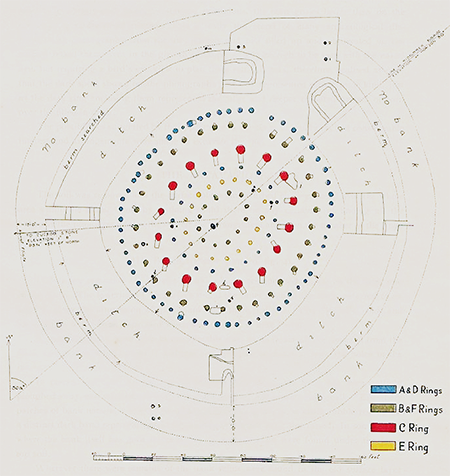
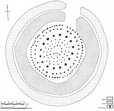
Fig. 5. Plans of Woodhenge showing the bank and ditch: (top) by Cunnington (1929, plate 3) and (bottom) by Wainwright & Longworth (1971, fig. 85, p. 208) (reproduced by kind permission of the Society of Antiquaries of London, © reserved)
The remains of small houses - perhaps seasonally occupied - were discovered in 2005 around and under the henge banks of Durrington Walls. These also date to c. 2,500 BC (Parker Pearson et al. 2005; Parker Pearson 2007: 132-140), but appear to relate to the timber circles enclosed by the henge banks rather than to the slightly later henge earthworks. About 500 years after these henge monuments were built, many burial mounds known as round barrows were constructed, some in linear cemeteries, particularly on the tops of the ridge lines overlooking Stonehenge.
It is difficult to be precise about the uses of the WHP and the many monuments within it, particularly as they were sometimes in use for many hundreds of years. It is certainly the case that large numbers of monuments in the area have a funerary element to them: the long barrows and round barrows were places of burial, and Stonehenge itself was used as a cremation cemetery, with the ashes of the dead placed in the Aubrey Holes. But other monuments do not appear to have a primary function as a place of burial. For example, Robin Hood’s Ball, the Lesser and Greater Cursus, the timber circles and the henges are more likely to have had ceremonial or meeting-place functions.
It is unclear what function the solstitial alignments at Stonehenge and other monuments in the WHP may have had. However, their significance is not in doubt and it is clear that they reflected the importance of the heavens to prehistoric peoples. Archaeologists have made various attempts to understand the cosmologies of these ancient peoples by studying these monuments. The intentionality of the lunar alignment of the Station-Stone rectangle is much less certain, and it has been claimed that Stonehenge was also important for other solar, lunar and even stellar events, but the evidence for this is even more tenuous.
Other sites for which solstitial alignments have been claimed include Coneybury henge (SU 1344 4160) and a ’new henge‘ discovered in 2010 by the University of Birmingham. However, the possible alignments at both of these sites are very broad and it is difficult to be sure that they were intentional; Coneybury has recently been discounted in any case (Ruggles, 2006: 17). Nor is there strong evidence that the earthwork enclosures themselves (e.g. at Woodhenge and Durrington Walls) were deliberately aligned (ibid.: 20). It has also been suggested that the Northern Circle at Durrington Walls (SU 1518 4379) may have solstitial alignments, but there is not enough evidence to consider them further. A setting of six timber postholes known as Durrington 68 (SU 1513 4325) has also been claimed to face midwinter sunrise, but this has recently been discounted (Ruggles 2014: 1233). Other monuments such as the Greater Cursus have recently been claimed to have alignments: Gaffney et al. (2012: 154) consider that there are two large pits that line up with the Heel Stone to form solstitial alignments. However, as it is also clear that there are other pits within the Cursus, and as the relevant fieldwork has not yet been fully published, it is not easy to assess these claims. None of these alignments will be considered further here, although it is possible—perhaps even likely—that other astronomical alignments and sites existed within the WHP and are waiting to be discovered.
Justification for inscription
Comparative analysis
Stonehenge WHP can and should be seen within a regional context of sites in the Neolithic and Bronze Age in north-west Europe that have astronomical alignments. These include monuments such as the Newgrange passage tomb, part of the Brú na Bóinne—Archaeological Ensemble of the Bend of the Boyne WHP (Prendergast 2014: 1273–1275), and various stone circles and monuments. All seem to have had some sort of funerary or ceremonial function, although astronomical practices in domestic contexts are also noted on occasion. This is more fully discussed elsewhere (Ruggles 2010, 28–34).
The monuments of the Stonehenge WHP provide the earliest evidence in Britain or Ireland of a consistent local practice of aligning monuments with some precision upon sunrise or sunset around the solstices. This is in contrast, for example, to the solstitial orientation of Newgrange, a “one-off” alignment among the Boyne Valley tombs (see Prendergast 2014); to the very broad pattern of orientation clustered around the intercardinal directions observed among Neolithic tombs and houses in the Orkney Islands (Parker Pearson and Richards 1994); and to evidence that Early Neolithic long barrows in the Salisbury Plain area, in the vicinity of Stonehenge—which preceded the construction of the Stonehenge stone circle by about a millennium—followed a broad pattern of orientation within the sun-rising/sun-climbing arcs, between north-east and south (Ruggles 1997: 212).
Integrity and/or authenticity
There is a statement of integrity and authenticity in the retrospective Statement of Outstanding Universal Value prepared for the Property in 2011 and recently adopted by UNESCO, which does set out some of the damage to astronomical alignments and sightlines. The relevant passages are quoted below:
Integrity
... The presence of busy roads going through the WHP impacts adversely on its integrity. The roads sever the relationship between Stonehenge and its surrounding monuments, notably the A344 which separates the Stone Circle from the Avenue.
Authenticity
... At Stonehenge, several monuments have retained their alignment on the Solstice sunrise and sunset, including the Stone Circle, the Avenue, Woodhenge, and the Durrington Walls Southern Circle and its Avenue.
Although the original ceremonial use of the monuments is not known, they retain spiritual significance for some people, and many still gather at both stone circles to celebrate the Solstice and other observations ...
We now consider these issues in more detail.
We have seen how the design of a number of monuments within the Stonehenge WHP had an astronomical significance. Some of these monuments are now largely or wholly buried and their astronomical significance is not readily apparent on the ground. Nevertheless, their remains are preserved underground and their authenticity and integrity are not affected. It is generally agreed that the solstitial alignments that form such a key element of the design at Stonehenge itself have not been impaired by intrusive modern structures, although the companions to the Heel Stone and Slaughter Stone are missing, as are some stones in the Sarsen Circle.
However, three monuments with astronomical significance have been directly damaged, all by roads. These are the Durrington Walls Avenue, the Durrington Walls Southern Circle, to which it leads, and the Stonehenge Avenue. The 200-year-old A344 road, which cuts off the Stonehenge Avenue from Stonehenge itself (see Fig. 3), was of concern to UNESCO at the time of inscription in 1986, and the British Government promised to close the road. Happily, this took place during 2013 as part of the Stonehenge Environmental Improvements Project, and Stonehenge is once again connected with its Avenue for the first time since at least the 18th century, when the turnpike road that became the A344 was first constructed. A modern embanked road (the A345) cuts across the Durrington Walls Avenue, and also buries part of the Southern Circle. The integrity of these important monuments is badly compromised by the presence of this road.
In prehistory, one or more observers would probably have stood at an appropriate point and viewed the sun or moon appearing or disappearing behind a distant horizon at specific times of the year. Thus, clear and unobstructed sightlines and horizons are important to aid our understanding of how these monuments functioned. Although the sightlines from the six monuments listed above are generally understood, it has not always been a straightforward matter to identify the ridge-line or horizon that would have originally been used, especially where intervening woods, road embankments and/or buildings currently block the view.
Table 2 assesses the integrity of the astronomical components of the WHP, with the proviso that the relevant sightlines and horizons are not yet fully understood. This detailed work needs to be done as part of the setting study and boundary review.
Table 2: Integrity of the astronomical components of the Stonehenge WHP.Attribute of OUV Component Integrity 4. The design of Neolithic and Bronze Age funerary and ceremonial sites and monuments in relation to the skies and astronomy Stone settings at Stonehenge (Bluestone and Trilithon horseshoes, Bluestone Circle, Sarsen Circle, Slaughter Stone and its companion, Heel Stone and its companion), and the relevant sightlines and horizons Generally good Stonehenge Avenue (straight segment closest to Stonehenge) and the relevant sightlines and horizons Bisected for 200 years by the A344; this road was removed in 2013 Woodhenge and the relevant sightlines and horizons Generally good Southern Circle, Durrington Walls and the relevant sightline and horizon Partly under the large A345 road embankment Southern Circle Avenue, Durrington Walls and the relevant sightline and horizon Partly under the large A345 road embankment Stonehenge Station-Stone rectangle and the relevant sightlines and horizons Generally good
The integrity of sightlines within the Stonehenge WHP
In assessing the integrity of these sightlines today, we make the assumption that they were largely kept clear in the Neolithic and Bronze Ages, so that the monuments could be used in the way in which we presume they were used, with the sun or moon rising or setting behind distant horizons visible from the monuments themselves. The sightlines are shown in Figs. 6 and 7. For a summary of the integrity of astronomical sightlines within the Stonehenge WHP, see Table 3 below.
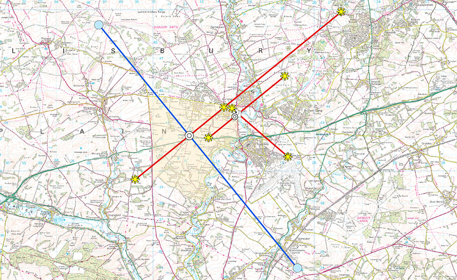
Fig. 6. Astronomical sightlines at Stonehenge World Heritage Site and the surrounding area, with their end-points on horizons. These should be treated as indicative rather than necessarily exact. The WHS area is shaded in yellow. Produced by Nick Hanks, Historic England, February 2015. © Crown Copyright and database right 2015. All rights reserved. Ordnance Survey Licence number 100024900
Sightline from Stonehenge looking southwest (midwinter sunset)
There is a growing consensus that the midwinter sightline was more important than the midsummer one, as discussed above. Today the integrity of this sightline, and its intermediate ridge lines and final horizon, is marred. Looking out from Stonehenge, the first problem is the A303 (0.5 km), which runs relatively close to the monument, and presents a considerable visual and noise intrusion to this alignment. Moving further south-west, the round barrow known as the Sun Barrow—which is on the alignment and on the Normanton Down ridge line—is intact (0.9 km), but the sightline then quickly runs into the plantation known as Normanton Gorse (1.1 km), which obscures it. Still further south-west is another plantation known as The Diamond (2.2 km), before the alignment continues towards the place that would form the visible horizon from Stonehenge in the absence of intervening vegetation, a hill WNW of Druid’s Lodge to the west of the A360 road (and outside the WHP) (4.4 km). This horizon is also obscured by yet another plantation, at The Park. The sightline appears to end just to the north of a much later Iron Age/ Romano-British oval enclosure, probably a settlement, which is situated near the hill top. It is difficult to determine the exact place because the various obstructions mean that we must rely upon computer modelling.
The Stonehenge Avenue looking south-west (midwinter sunset) shares the same alignment, and the same issues apply regarding its integrity. On the initial approach towards Stonehenge along the Avenue from the ’elbow‘ at Stonehenge Bottom, Stonehenge itself forms the horizon; the more distant landscape only appears during the final stages of the approach.
Sightline from Stonehenge looking north-east (midsummer sunrise)
The A344 has now been closed to traffic and, once the grass has regenerated, visitors will be able to walk uninterrupted from Stonehenge to its Avenue for the first time in centuries. The integrity of this sightline is good for 1.7km until it hits the line of trees to the immediate north of the Cursus which obscure it (these were planted to screen the view of the Steel Houses from Stonehenge). Further to the north-east, by good fortune it avoids buildings within the Larkhill Garrison (although not some garrison roads), and its final horizon is probably the ridge along which the Packway road runs (3.0 km). Alternately, it may continue into the Salisbury Plain Training Area, with the visible horizon formed by a ridge just to the south of Sidbury Hill hillfort, some 12km from Stonehenge. It is difficult to check which ridge forms the final horizon because of the Cursus Northern Plantation, which compromises all views further to the north-east: again, computer modelling is needed.
The Stonehenge Avenue looking north-east (midsummer sunrise) shares the same alignment, and the same issues apply regarding its integrity.
Sightlines from the Stonehenge Station-Stone rectangle looking south-east (southernmost moonrise)
(This is assessed as a single line in the landscape, not two parallel lines.) Today the integrity of this sightline, and its intermediate ridge lines and final horizon, is marred. Looking out from Stonehenge, the first problem is the A303 (0.2km), which runs relatively close to the monument, and presents a considerable visual and noise intrusion to this alignment. Further south-east, it is obscured by the Luxenborough Plantation (1.0 km), which obscures the first ridge line it hits at Coneybury Hill. The alignment continues over the Avon Valley and outside the WHP boundary. It just misses the Field Barn Buildings (4 km) on the east side of the Avon, but is further obscured by the Cocked Hat plantation (5 km), which lies near another ridge line on which the A345 runs. After crossing the A345 (where there is some new planting which will also grow and obscure the line more in future), the alignment runs as far as the chalk ridge on which the hillfort of Figsbury Ring sits (10.5 km), where its original horizon was probably located (but passing just north of Figsbury Ring itself, and to the south of the highest point of the ridge). Again, computer modelling is needed to construct the exact sightlines, as the obstructions make it is difficult to check on the ground, but the view back from Figsbury Ring into the WHP is helpful.
Sightlines from the Stonehenge Station-Stone rectangle looking north-west (northernmost moonset)
(This is assessed as a single line in the landscape, not two parallel lines.) This sightline has relatively good integrity for some distance. The A344 has been closed, and from Stonehenge the alignment runs north-west through the WHP to the Lesser Cursus ridge line, then runs outside the WHP into the Salisbury Plain Training Area with few interruptions. It is obscured by the caravan park at the Bustard Inn (5 km), and its final horizon may have been the ridge at Westdown Artillery Range (12 km), subject to confirmation by computer modelling.
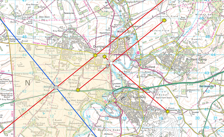
Fig. 7. Astronomical sightlines at Stonehenge, Woodhenge, and Durrington Walls Southern Circle and Avenue. These should be treated as indicative rather than necessarily exact. The WHS area is shaded in yellow. Produced by Nick Hanks, Historic England, February 2015. © Crown Copyright and database right 2015. All rights reserved. Ordnance Survey Licence number 100024900
Sightline from Woodhenge looking north-east (midsummer sunrise)
This is a relatively well-preserved alignment. Although it runs through groups of buildings in the village of Durrington, these are relatively low-lying and do not obscure it. The final horizon appears to be outside the WHP at Silk Hill in the Salisbury Plain Training Area (5.3 km).
Sightline from Woodhenge looking south-west (midwinter sunset)
This is a relatively well-preserved sightline as far as its horizon, which is probably at King Barrow Ridge (2.0 km), which sits slightly higher than Woodhenge. It is difficult to be precise about this because today there are numerous trees on the ridge that forms the horizon, together with the Stonehenge Cottages and also the New King Barrows themselves, although the sightline is well preserved up until this point. If the alignment continued, it would eventually hit the Lake Barrow Group (5 km).
Sightline from the Southern Circle, Durrington Walls, looking south-east (midwinter sunrise)
This is wholly destroyed by the embankment of the A345, which sits over half the monument. If it were not destroyed, the alignment would swiftly run south-east outside the WHP over the Avon Valley and into the modern industrial development of Solstice Park (whose name is coincidental). The horizon for this alignment is the Earl’s Farm Down ridge (4.2 km), near to round barrow group SM 28925 and Bowl Barrow SM 28946. Despite much development in this area, this horizon appears to be intact, with large modern buildings currently sitting below it.
Sightline from the Southern Circle Avenue, Durrington Walls, looking north-west (midsummer sunset)
This is wholly destroyed by the embankment of the A345, which sits over part of the Avenue, severing the Avenue from the Southern Circle. If the road were not there, the horizon for this sightline would be the north-westerly banks of Durrington Walls henge (0.7 km).
Table 3: Summary of the integrity of astronomical sightlines within the Stonehenge WHP. Sightline (alignment) Integrity Horizon 1 Stonehenge looking south-west (midwinter sunset) Line obscured by A303 and several plantations. Probably hill ~1km to WNW of Druid’s Lodge (4.4 km). 2 Stonehenge looking north-east (midsummer sunrise) A344 now closed, but line obscured by a plantation and the Packway road. Packway ridge (3.0 km) or Sidbury Hill, south of hillfort (12 km). The latter intact, the former obscured. 3 Stonehenge Avenue looking south-west (midwinter sunset) Line obscured by A303 and several plantations. Probably hill ~1km to WNW of Druid’s Lodge (4.4 km). 4 Stonehenge Avenue looking north-east (midsummer sunrise) A344 now closed, but line obscured by a plantation and the Packway road. Packway ridge (3.0 km) or Sidbury Hill, south of hillfort (12 km). The latter intact, the former obscured. 5 Stonehenge Station-Stone rectangle looking south-east (southernmost moonrise) (This is assessed as a single line in the landscape, not two parallel lines). Line obscured by A303 and several plantations. Probably the ridge line on which Figsbury Ring hillfort sits (10.5 km). Intact. 6 Stonehenge Station-Stone Rectangle looking north-west (northernmost moonset) (This is assessed as a single line in the landscape, not two parallel lines). Relatively good for several km. Probably Westdown Artillery range (12 km). Intact. 7 Woodhenge looking north-east (midsummer sunrise) Relatively good for several km. Silk Hill (5.3 km). Intact. 8 Woodhenge looking south-west (midwinter sunset) Good. Probably King Barrow Ridge (2.0 km). Exact point obscured by trees. 9 Southern Circle, Durrington Walls, looking south-east (midwinter sunrise) Destroyed by A345 embankment. Earl’s Farm Down ridge (4.2 km). Intact. 10 Southern Circle Avenue, Durrington Walls, looking north-west (midsummer sunset) Destroyed by A345 embankment. Durrington Walls henge banks (0.7 km). Intact.
The integrity of sightlines and the boundary of the Stonehenge WHP
It is recommended here that the minor boundary review and setting study for the WHP (see ’Maps and plans‘ above), and any for a buffer zone, should also consider the solstitial alignments of those monuments that are known to have had them, to ensure that the relevant and appropriate horizons and sightlines are taken into account within any new boundary or future buffer zone. This will probably require some computer modelling (which should be done using topographic modelling excluding vegetation and buildings) and ground-truthing by field observation and measurement as required. We know that not all the relevant horizons and sightlines are already captured within the existing boundary, but this needs to be checked in detail. Any extensions needed should fall within the scope of a minor boundary review (UNESCO 2011: paras 163-4), because UNESCO’s Statement of Outstanding Universal Value (OUV) for Stonehenge already recognises its astronomical importance, or could come within the scope of a new buffer zone, as at Studley Royal and Fountains Abbey WHP—see Fig. 8.
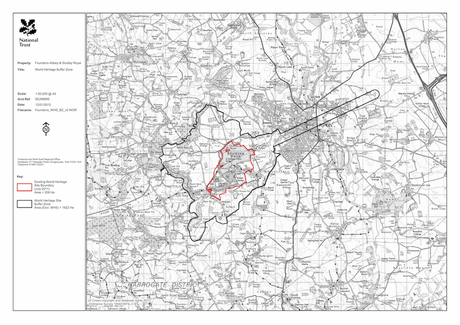
Fig. 8. The UNESCO-adopted Fountains Abbey buffer zone, which includes a (non-astronomical) sightline. © National Trust
Criteria under which inscription might be proposed
England, United Kingdom
State/Province/Region
County of Wiltshire
Name
Stonehenge, Avebury and Associated Sites
Geographical co-ordinates and/or UTM
Monument NGR Latitude Longitude Elevation Stonehenge SU 1225 4219 51° 10′ 44″ N 1° 49′ 34″ W 102 m Woodhenge SU 1505 4338 51° 11′ 22″ N 1° 47′ 10″ W 98 m Southern Circle, Durrington Walls SU 1514 4366 51° 11′ 31″ N 1° 47′ 05″ W 88 m
Maps and plans,
showing boundaries of property and buffer zone
Fig. 1. Map of the Stonehenge World Heritage Site. Based on scheduled monument information from the English Heritage GIS combined with features drawn from Ordnance Survey mapping data. © Historic England
The current boundary is as shown in Map 1 in the Stonehenge WHS Management Plan 2009 (Young, Chadburn and Bedu 2009: 175) (see Fig. 1). There is no buffer zone, but the current Stonehenge WHS Committee considers that a setting study should be carried out (Simmonds and Thomas 2015: Policy 2b/ Action 15). Earlier policies had considered that a buffer zone was not needed if current government guidance was followed (National Planning Policy Framework, 2012; Circular 07/2009 on The Protection of World Heritage Sites; The Protection & Management of World Heritage Sites in England, English Heritage Guidance Note to Circular for England on the Protection of World Heritage Sites 2009).
A minor boundary review is currently under way (2015), being one of the actions recommended in the 2009 Stonehenge Management Plan (Young, Chadburn and Bedu 2009: 120).
The Avebury part of the World Heritage Property is not considered further here, as there is no secure evidence for astronomical importance, other than the general one which is noted in southern Britain, that most of its long barrows are roughly aligned towards the sun-climbing or sun-rising parts of the sky (Ruggles 2012).
Area of property and buffer zone
Stonehenge World Heritage Property (WHP) currently comprises an area of 2,665 hectares (26.6 km2) of land with Stonehenge at its approximate centre. There is no buffer zone.
Description
Description of the property
Stonehenge WHP forms one half of the Stonehenge, Avebury and Associated Sites WHP, which is internationally important for its complexes of outstanding prehistoric funerary and ceremonial monuments of the Neolithic and Early Bronze Age. Stonehenge is the most architecturally sophisticated prehistoric stone circle in the world and, in addition, the WHP around it contains many hundreds of archaeological sites and monuments, many of which are prehistoric too. These monuments in their associated landscapes help us to understand Neolithic and Bronze Age ceremonial and mortuary practices in England and indeed in north-west Europe. They demonstrate around 2000 years of continuous use and monument building between c. 3700 BC and 1600 BC.
One of the most important features of Stonehenge – one that has been recognised since the 18th century when it was noted by the antiquarian William Stukeley – is that its principal axis of symmetry is aligned upon winter solstice (“midwinter”) sunset in one direction and summer solstice (“midsummer”) sunrise in the other. We now know that a number of other prehistoric sites in the Stonehenge WHP also have astronomical significance, with some monuments oriented towards midwinter sunset and/or midsummer sunrise and others towards midsummer sunset or midwinter sunrise (Ruggles 2006; 2014). This contrasts with Avebury, where there are no known sites that convincingly demonstrate deliberate alignment in any of the solstitial directions.
See also the official brief description of the property that was agreed by UNESCO in July 2008 (quoted in Young, Chadburn and Bedu 2009: 21, section 3.2). A more detailed description of the Stonehenge WHP is set out in Appendix G (ibid.).
Six monuments in the Stonehenge WHP are considered to have significant astronomical alignments:
- Stone settings at Stonehenge (Bluestone horseshoe, Trilithon horseshoe, Bluestone Circle, Sarsen Circle, Slaughter Stone and its companion, Heel Stone and its companion)
- Stonehenge Avenue (straight segment closest to Stonehenge)
- Woodhenge (timber circles rings C–F and grave)
- Southern Circle, Durrington Walls
- Southern Circle Avenue, Durrington Walls
- Stonehenge Station-Stone rectangle
More details on these sites and alignments can be found in the section below and in Table 1.
Table 1: Summary of significant astronomical alignments in the Stonehenge WHP, with reference to the sites and components that might carry the OUV of the WHP in relation to astronomy.
Attribute of OUV Component Likely alignment Likely date of
construction 4. The design of Neolithic and Bronze Age funerary and ceremonial sites and monuments in relation to the skies and astronomy Stone settings at Stonehenge (Bluestone and Trilithon horseshoes, Bluestone Circle, Sarsen Circle, Slaughter Stone and its companion, Heel Stone and its companion), and the relevant sightlines and horizons Midwinter sunset (but could also be midsummer sunrise) c. 2500 BC Stonehenge Avenue (straight segment closest to Stonehenge) and the relevant sightlines and horizons Midwinter sunset (but could also be midsummer sunrise) c. 2300 BC Woodhenge and the relevant sightlines and horizons Midwinter sunset (but could also be midsummer sunrise) c. 2500 BC Southern Circle, Durrington Walls and the relevant sightline and horizon Midwinter sunrise c. 2500 BC Southern Circle Avenue, Durrington Walls and the relevant sightline and horizon Midsummer sunset c. 2500 BC Stonehenge Station-Stone rectangle and the relevant sightlines and horizons Most southerly moonrise/ most northerly moonset and Midsummer sunrise/ midwinter sunset c. 2500 BC
History and development
The first ’monument‘ at Stonehenge WHP comprised an alignment of three Mesolithic pits (c. 8,000 BC) located just to the north-west of Stonehenge monument, which apparently contained huge timber posts. But the area became more intensively used from the early and middle Neolithic onwards (c. 4,000-3,000 BC), with the construction of a number of funerary and ceremonial monuments such as Neolithic long barrows (communal burial mounds) and a causewayed enclosure known as Robin Hood’s Ball. Two long earthwork enclosures known as Cursuses - the Greater and Lesser - were also built towards the end of this period.
The lengthy history of Stonehenge itself started around 3,000 BC with the construction of a circular enclosure formed by a bank and ditch, containing the 56 pits known as the Aubrey Holes. Later, stones were added to the monument c. 2,500 BC, culminating in the construction of the stone circle, the remains of which we see today.
This stone-circle phase of the monument is the one that has the most readily apparent astronomical importance, with the axis of symmetry through the Bluestone and Trilithon horseshoes, between the Slaughter Stone and its companion, and between the Heel Stone and its companion, being aligned towards midwinter sunset in one direction and midsummer sunrise in the other (Ruggles 2006). Additionally, it is clear that the Sarsen Circle and Bluestone Circle are not completely regular, and were arranged and worked to respect the solstitial alignment, particularly the midwinter sunset alignment (Abbott and Anderson-Whymark 2012; 18, 20-22, 25, 50-53). It may also have been significant that the rectangle of four Station Stones just outside the bank and ditch, which may pre-date the Sarsen Circle, is broadly aligned lengthways upon the most southerly possible rising position and the most northerly setting position of the moon, as well as following the main solstitial axis across its width in the perpendicular direction (Ruggles 1997: 219-220). It is interesting and almost certainly not a coincidence that the width of the Station-Stone rectangle just exceeds the diameter of the Sarsen Circle, so it is possible that these lunar alignments could have been viewed even with the Sarsen Circle in place (Ruggles 2014: 1235).
Fig. 2. The midwinter sunset at Stonehenge taken from the Stonehenge Avenue, and showing the setting winter solstice sun seen through the monument. Photograph by James O. Davies, © Historic England (Photo Library N030018)
Fig. 3. The Stonehenge Avenue is aligned on the solstitial axis. In places, periglacial stripes appear to run parallel with it—one stripe is apparently visible as a shallow linear depression just to the left of the Avenue on this photograph. © 1994 Crown Copyright, Historic England NMR 15041_26
The builders dragged stones for Stonehenge weighing up to 40 tonnes, from distances up to 240km away. They engineered the monument exactly so that the midwinter sun set between the two largest stones (the great trilithon and its fallen companion), and probably between the Heel Stone and its now-lost companion, and the Slaughter Stone and its lost companion, if one were viewing this sunset from the Avenue (Fig. 2). The midsummer sunrise may also have been important to the original builders. Standing with their backs to the largest trilithon, and looking down the Stonehenge Avenue, they could have seen the sun rise over the horizon to the north-east. Although the summer solstice is the main focus for modern celebrations, most scholars consider it much more likely that the stones were originally used mainly at midwinter (Fernie 1994: 155-156). This view has recently been strengthened by the results of a laser-scan at Stonehenge commissioned by English Heritage in 2011 and a subsequent archaeological analysis of the results in 2012. These have revealed that much more care was taken in dressing the stones that would be visible when approaching the monument from its Avenue: the stones in the Sarsen Circle at this point were all completely pick-dressed to remove the uneven surface. By contrast, the stones at the very ’back‘ of the monument (for example, the outer faces of the sarsen stones on the south-west side of the circle) were not dressed or shaped with the same care and attention (Abbott and Anderson-Whymark 2012).
Part of the Stonehenge Avenue (c. 2,300 BC) itself is aligned along the main ’solstitial axis‘ of Stonehenge (Fig. 3), and this part is still visible as an earthwork (Fig. 4). Excavations and recent geophysical surveys along its length have revealed buried linear geological features known as periglacial stripes, which might have been visible above ground during prehistory, for example through differential vegetation growth. In places, some of these stripes appear to be aligned on the solstitial axis, and the Avenue may have been built to formalise this natural phenomenon: this may be one of the reasons why the area was special to prehistoric peoples (Parker Pearson 2012: 240-248; Ruggles 2014: 1234).
Fig. 4. Two views of the Stonehenge Avenue ditches under excavation, August 2013. Photographs by Adam Stanford, Aerial-Cam. © English Heritage
Also built during this period around 2,500-2,300 BC were a number of other monuments, including Durrington Walls henge and Woodhenge, which also appear to contain solstitial alignments. Woodhenge is interesting because the solstitial alignment is manifested in the oval shape of its concentric timber rings, rather than the position of the earthwork henge entrance. A closer examination of the plan (see Fig. 5, top) reveals that the outer two rings (A and B) appear to be less regular in plan and have entrances that appear to match the henge entrance rather than being on the solstitial alignment. The outer rings A and B appear less regular in plan than the inner rings, and are also placed at a slight distance from them. When one considers the archaeological evidence for the post-holes, Rings A and B are variable in depth whereas the others are more consistent in their depths and dimensions. The inner four timber rings (C, D, E and F) are oval in shape and are certainly solstitially aligned. This suggests that Rings A and B are likely to be of a different date from rings C-F. While the dating evidence currently available for this monument is insufficiently precise to prove this conclusively, it seems likely that there are two phases of timber rings, and that only the inner rings can be considered to be of astronomical importance.
The entrance of the Southern Circle, a set of six concentric timber rings that stood within Durrington Walls (see Fig. 5, bottom), was aligned south-eastwards towards midwinter sunrise, whereas the short Avenue (the ’Southern Circle Avenue‘) was approximately aligned upon (within 1.5 degrees of) midsummer sunset towards the north-west (Ruggles 2006; 2014: 1232-1233). These two solstitial directions deviate by several degrees from being opposite to each other at this location because of the high horizon to the north-west.
Fig. 5. Plans of Woodhenge showing the bank and ditch: (top) by Cunnington (1929, plate 3) and (bottom) by Wainwright & Longworth (1971, fig. 85, p. 208) (reproduced by kind permission of the Society of Antiquaries of London, © reserved)
The remains of small houses - perhaps seasonally occupied - were discovered in 2005 around and under the henge banks of Durrington Walls. These also date to c. 2,500 BC (Parker Pearson et al. 2005; Parker Pearson 2007: 132-140), but appear to relate to the timber circles enclosed by the henge banks rather than to the slightly later henge earthworks. About 500 years after these henge monuments were built, many burial mounds known as round barrows were constructed, some in linear cemeteries, particularly on the tops of the ridge lines overlooking Stonehenge.
It is difficult to be precise about the uses of the WHP and the many monuments within it, particularly as they were sometimes in use for many hundreds of years. It is certainly the case that large numbers of monuments in the area have a funerary element to them: the long barrows and round barrows were places of burial, and Stonehenge itself was used as a cremation cemetery, with the ashes of the dead placed in the Aubrey Holes. But other monuments do not appear to have a primary function as a place of burial. For example, Robin Hood’s Ball, the Lesser and Greater Cursus, the timber circles and the henges are more likely to have had ceremonial or meeting-place functions.
It is unclear what function the solstitial alignments at Stonehenge and other monuments in the WHP may have had. However, their significance is not in doubt and it is clear that they reflected the importance of the heavens to prehistoric peoples. Archaeologists have made various attempts to understand the cosmologies of these ancient peoples by studying these monuments. The intentionality of the lunar alignment of the Station-Stone rectangle is much less certain, and it has been claimed that Stonehenge was also important for other solar, lunar and even stellar events, but the evidence for this is even more tenuous.
Other sites for which solstitial alignments have been claimed include Coneybury henge (SU 1344 4160) and a ’new henge‘ discovered in 2010 by the University of Birmingham. However, the possible alignments at both of these sites are very broad and it is difficult to be sure that they were intentional; Coneybury has recently been discounted in any case (Ruggles, 2006: 17). Nor is there strong evidence that the earthwork enclosures themselves (e.g. at Woodhenge and Durrington Walls) were deliberately aligned (ibid.: 20). It has also been suggested that the Northern Circle at Durrington Walls (SU 1518 4379) may have solstitial alignments, but there is not enough evidence to consider them further. A setting of six timber postholes known as Durrington 68 (SU 1513 4325) has also been claimed to face midwinter sunrise, but this has recently been discounted (Ruggles 2014: 1233). Other monuments such as the Greater Cursus have recently been claimed to have alignments: Gaffney et al. (2012: 154) consider that there are two large pits that line up with the Heel Stone to form solstitial alignments. However, as it is also clear that there are other pits within the Cursus, and as the relevant fieldwork has not yet been fully published, it is not easy to assess these claims. None of these alignments will be considered further here, although it is possible—perhaps even likely—that other astronomical alignments and sites existed within the WHP and are waiting to be discovered.
Justification for inscription
Comparative analysis
Stonehenge WHP can and should be seen within a regional context of sites in the Neolithic and Bronze Age in north-west Europe that have astronomical alignments. These include monuments such as the Newgrange passage tomb, part of the Brú na Bóinne—Archaeological Ensemble of the Bend of the Boyne WHP (Prendergast 2014: 1273–1275), and various stone circles and monuments. All seem to have had some sort of funerary or ceremonial function, although astronomical practices in domestic contexts are also noted on occasion. This is more fully discussed elsewhere (Ruggles 2010, 28–34).
The monuments of the Stonehenge WHP provide the earliest evidence in Britain or Ireland of a consistent local practice of aligning monuments with some precision upon sunrise or sunset around the solstices. This is in contrast, for example, to the solstitial orientation of Newgrange, a “one-off” alignment among the Boyne Valley tombs (see Prendergast 2014); to the very broad pattern of orientation clustered around the intercardinal directions observed among Neolithic tombs and houses in the Orkney Islands (Parker Pearson and Richards 1994); and to evidence that Early Neolithic long barrows in the Salisbury Plain area, in the vicinity of Stonehenge—which preceded the construction of the Stonehenge stone circle by about a millennium—followed a broad pattern of orientation within the sun-rising/sun-climbing arcs, between north-east and south (Ruggles 1997: 212).
Integrity and/or authenticity
There is a statement of integrity and authenticity in the retrospective Statement of Outstanding Universal Value prepared for the Property in 2011 and recently adopted by UNESCO, which does set out some of the damage to astronomical alignments and sightlines. The relevant passages are quoted below:
Integrity
... The presence of busy roads going through the WHP impacts adversely on its integrity. The roads sever the relationship between Stonehenge and its surrounding monuments, notably the A344 which separates the Stone Circle from the Avenue.
Authenticity
... At Stonehenge, several monuments have retained their alignment on the Solstice sunrise and sunset, including the Stone Circle, the Avenue, Woodhenge, and the Durrington Walls Southern Circle and its Avenue.
Although the original ceremonial use of the monuments is not known, they retain spiritual significance for some people, and many still gather at both stone circles to celebrate the Solstice and other observations ...
We now consider these issues in more detail.
We have seen how the design of a number of monuments within the Stonehenge WHP had an astronomical significance. Some of these monuments are now largely or wholly buried and their astronomical significance is not readily apparent on the ground. Nevertheless, their remains are preserved underground and their authenticity and integrity are not affected. It is generally agreed that the solstitial alignments that form such a key element of the design at Stonehenge itself have not been impaired by intrusive modern structures, although the companions to the Heel Stone and Slaughter Stone are missing, as are some stones in the Sarsen Circle.
However, three monuments with astronomical significance have been directly damaged, all by roads. These are the Durrington Walls Avenue, the Durrington Walls Southern Circle, to which it leads, and the Stonehenge Avenue. The 200-year-old A344 road, which cuts off the Stonehenge Avenue from Stonehenge itself (see Fig. 3), was of concern to UNESCO at the time of inscription in 1986, and the British Government promised to close the road. Happily, this took place during 2013 as part of the Stonehenge Environmental Improvements Project, and Stonehenge is once again connected with its Avenue for the first time since at least the 18th century, when the turnpike road that became the A344 was first constructed. A modern embanked road (the A345) cuts across the Durrington Walls Avenue, and also buries part of the Southern Circle. The integrity of these important monuments is badly compromised by the presence of this road.
In prehistory, one or more observers would probably have stood at an appropriate point and viewed the sun or moon appearing or disappearing behind a distant horizon at specific times of the year. Thus, clear and unobstructed sightlines and horizons are important to aid our understanding of how these monuments functioned. Although the sightlines from the six monuments listed above are generally understood, it has not always been a straightforward matter to identify the ridge-line or horizon that would have originally been used, especially where intervening woods, road embankments and/or buildings currently block the view.
Table 2 assesses the integrity of the astronomical components of the WHP, with the proviso that the relevant sightlines and horizons are not yet fully understood. This detailed work needs to be done as part of the setting study and boundary review.
Table 2: Integrity of the astronomical components of the Stonehenge WHP.Attribute of OUV Component Integrity 4. The design of Neolithic and Bronze Age funerary and ceremonial sites and monuments in relation to the skies and astronomy Stone settings at Stonehenge (Bluestone and Trilithon horseshoes, Bluestone Circle, Sarsen Circle, Slaughter Stone and its companion, Heel Stone and its companion), and the relevant sightlines and horizons Generally good Stonehenge Avenue (straight segment closest to Stonehenge) and the relevant sightlines and horizons Bisected for 200 years by the A344; this road was removed in 2013 Woodhenge and the relevant sightlines and horizons Generally good Southern Circle, Durrington Walls and the relevant sightline and horizon Partly under the large A345 road embankment Southern Circle Avenue, Durrington Walls and the relevant sightline and horizon Partly under the large A345 road embankment Stonehenge Station-Stone rectangle and the relevant sightlines and horizons Generally good
The integrity of sightlines within the Stonehenge WHP
In assessing the integrity of these sightlines today, we make the assumption that they were largely kept clear in the Neolithic and Bronze Ages, so that the monuments could be used in the way in which we presume they were used, with the sun or moon rising or setting behind distant horizons visible from the monuments themselves. The sightlines are shown in Figs. 6 and 7. For a summary of the integrity of astronomical sightlines within the Stonehenge WHP, see Table 3 below.
Fig. 6. Astronomical sightlines at Stonehenge World Heritage Site and the surrounding area, with their end-points on horizons. These should be treated as indicative rather than necessarily exact. The WHS area is shaded in yellow. Produced by Nick Hanks, Historic England, February 2015. © Crown Copyright and database right 2015. All rights reserved. Ordnance Survey Licence number 100024900
Sightline from Stonehenge looking southwest (midwinter sunset)
There is a growing consensus that the midwinter sightline was more important than the midsummer one, as discussed above. Today the integrity of this sightline, and its intermediate ridge lines and final horizon, is marred. Looking out from Stonehenge, the first problem is the A303 (0.5 km), which runs relatively close to the monument, and presents a considerable visual and noise intrusion to this alignment. Moving further south-west, the round barrow known as the Sun Barrow—which is on the alignment and on the Normanton Down ridge line—is intact (0.9 km), but the sightline then quickly runs into the plantation known as Normanton Gorse (1.1 km), which obscures it. Still further south-west is another plantation known as The Diamond (2.2 km), before the alignment continues towards the place that would form the visible horizon from Stonehenge in the absence of intervening vegetation, a hill WNW of Druid’s Lodge to the west of the A360 road (and outside the WHP) (4.4 km). This horizon is also obscured by yet another plantation, at The Park. The sightline appears to end just to the north of a much later Iron Age/ Romano-British oval enclosure, probably a settlement, which is situated near the hill top. It is difficult to determine the exact place because the various obstructions mean that we must rely upon computer modelling.
The Stonehenge Avenue looking south-west (midwinter sunset) shares the same alignment, and the same issues apply regarding its integrity. On the initial approach towards Stonehenge along the Avenue from the ’elbow‘ at Stonehenge Bottom, Stonehenge itself forms the horizon; the more distant landscape only appears during the final stages of the approach.
Sightline from Stonehenge looking north-east (midsummer sunrise)
The A344 has now been closed to traffic and, once the grass has regenerated, visitors will be able to walk uninterrupted from Stonehenge to its Avenue for the first time in centuries. The integrity of this sightline is good for 1.7km until it hits the line of trees to the immediate north of the Cursus which obscure it (these were planted to screen the view of the Steel Houses from Stonehenge). Further to the north-east, by good fortune it avoids buildings within the Larkhill Garrison (although not some garrison roads), and its final horizon is probably the ridge along which the Packway road runs (3.0 km). Alternately, it may continue into the Salisbury Plain Training Area, with the visible horizon formed by a ridge just to the south of Sidbury Hill hillfort, some 12km from Stonehenge. It is difficult to check which ridge forms the final horizon because of the Cursus Northern Plantation, which compromises all views further to the north-east: again, computer modelling is needed.
The Stonehenge Avenue looking north-east (midsummer sunrise) shares the same alignment, and the same issues apply regarding its integrity.
Sightlines from the Stonehenge Station-Stone rectangle looking south-east (southernmost moonrise)
(This is assessed as a single line in the landscape, not two parallel lines.) Today the integrity of this sightline, and its intermediate ridge lines and final horizon, is marred. Looking out from Stonehenge, the first problem is the A303 (0.2km), which runs relatively close to the monument, and presents a considerable visual and noise intrusion to this alignment. Further south-east, it is obscured by the Luxenborough Plantation (1.0 km), which obscures the first ridge line it hits at Coneybury Hill. The alignment continues over the Avon Valley and outside the WHP boundary. It just misses the Field Barn Buildings (4 km) on the east side of the Avon, but is further obscured by the Cocked Hat plantation (5 km), which lies near another ridge line on which the A345 runs. After crossing the A345 (where there is some new planting which will also grow and obscure the line more in future), the alignment runs as far as the chalk ridge on which the hillfort of Figsbury Ring sits (10.5 km), where its original horizon was probably located (but passing just north of Figsbury Ring itself, and to the south of the highest point of the ridge). Again, computer modelling is needed to construct the exact sightlines, as the obstructions make it is difficult to check on the ground, but the view back from Figsbury Ring into the WHP is helpful.
Sightlines from the Stonehenge Station-Stone rectangle looking north-west (northernmost moonset)
(This is assessed as a single line in the landscape, not two parallel lines.) This sightline has relatively good integrity for some distance. The A344 has been closed, and from Stonehenge the alignment runs north-west through the WHP to the Lesser Cursus ridge line, then runs outside the WHP into the Salisbury Plain Training Area with few interruptions. It is obscured by the caravan park at the Bustard Inn (5 km), and its final horizon may have been the ridge at Westdown Artillery Range (12 km), subject to confirmation by computer modelling.
Fig. 7. Astronomical sightlines at Stonehenge, Woodhenge, and Durrington Walls Southern Circle and Avenue. These should be treated as indicative rather than necessarily exact. The WHS area is shaded in yellow. Produced by Nick Hanks, Historic England, February 2015. © Crown Copyright and database right 2015. All rights reserved. Ordnance Survey Licence number 100024900
Sightline from Woodhenge looking north-east (midsummer sunrise)
This is a relatively well-preserved alignment. Although it runs through groups of buildings in the village of Durrington, these are relatively low-lying and do not obscure it. The final horizon appears to be outside the WHP at Silk Hill in the Salisbury Plain Training Area (5.3 km).
Sightline from Woodhenge looking south-west (midwinter sunset)
This is a relatively well-preserved sightline as far as its horizon, which is probably at King Barrow Ridge (2.0 km), which sits slightly higher than Woodhenge. It is difficult to be precise about this because today there are numerous trees on the ridge that forms the horizon, together with the Stonehenge Cottages and also the New King Barrows themselves, although the sightline is well preserved up until this point. If the alignment continued, it would eventually hit the Lake Barrow Group (5 km).
Sightline from the Southern Circle, Durrington Walls, looking south-east (midwinter sunrise)
This is wholly destroyed by the embankment of the A345, which sits over half the monument. If it were not destroyed, the alignment would swiftly run south-east outside the WHP over the Avon Valley and into the modern industrial development of Solstice Park (whose name is coincidental). The horizon for this alignment is the Earl’s Farm Down ridge (4.2 km), near to round barrow group SM 28925 and Bowl Barrow SM 28946. Despite much development in this area, this horizon appears to be intact, with large modern buildings currently sitting below it.
Sightline from the Southern Circle Avenue, Durrington Walls, looking north-west (midsummer sunset)
This is wholly destroyed by the embankment of the A345, which sits over part of the Avenue, severing the Avenue from the Southern Circle. If the road were not there, the horizon for this sightline would be the north-westerly banks of Durrington Walls henge (0.7 km).
Table 3: Summary of the integrity of astronomical sightlines within the Stonehenge WHP. Sightline (alignment) Integrity Horizon 1 Stonehenge looking south-west (midwinter sunset) Line obscured by A303 and several plantations. Probably hill ~1km to WNW of Druid’s Lodge (4.4 km). 2 Stonehenge looking north-east (midsummer sunrise) A344 now closed, but line obscured by a plantation and the Packway road. Packway ridge (3.0 km) or Sidbury Hill, south of hillfort (12 km). The latter intact, the former obscured. 3 Stonehenge Avenue looking south-west (midwinter sunset) Line obscured by A303 and several plantations. Probably hill ~1km to WNW of Druid’s Lodge (4.4 km). 4 Stonehenge Avenue looking north-east (midsummer sunrise) A344 now closed, but line obscured by a plantation and the Packway road. Packway ridge (3.0 km) or Sidbury Hill, south of hillfort (12 km). The latter intact, the former obscured. 5 Stonehenge Station-Stone rectangle looking south-east (southernmost moonrise) (This is assessed as a single line in the landscape, not two parallel lines). Line obscured by A303 and several plantations. Probably the ridge line on which Figsbury Ring hillfort sits (10.5 km). Intact. 6 Stonehenge Station-Stone Rectangle looking north-west (northernmost moonset) (This is assessed as a single line in the landscape, not two parallel lines). Relatively good for several km. Probably Westdown Artillery range (12 km). Intact. 7 Woodhenge looking north-east (midsummer sunrise) Relatively good for several km. Silk Hill (5.3 km). Intact. 8 Woodhenge looking south-west (midwinter sunset) Good. Probably King Barrow Ridge (2.0 km). Exact point obscured by trees. 9 Southern Circle, Durrington Walls, looking south-east (midwinter sunrise) Destroyed by A345 embankment. Earl’s Farm Down ridge (4.2 km). Intact. 10 Southern Circle Avenue, Durrington Walls, looking north-west (midsummer sunset) Destroyed by A345 embankment. Durrington Walls henge banks (0.7 km). Intact.
The integrity of sightlines and the boundary of the Stonehenge WHP
It is recommended here that the minor boundary review and setting study for the WHP (see ’Maps and plans‘ above), and any for a buffer zone, should also consider the solstitial alignments of those monuments that are known to have had them, to ensure that the relevant and appropriate horizons and sightlines are taken into account within any new boundary or future buffer zone. This will probably require some computer modelling (which should be done using topographic modelling excluding vegetation and buildings) and ground-truthing by field observation and measurement as required. We know that not all the relevant horizons and sightlines are already captured within the existing boundary, but this needs to be checked in detail. Any extensions needed should fall within the scope of a minor boundary review (UNESCO 2011: paras 163-4), because UNESCO’s Statement of Outstanding Universal Value (OUV) for Stonehenge already recognises its astronomical importance, or could come within the scope of a new buffer zone, as at Studley Royal and Fountains Abbey WHP—see Fig. 8.
Fig. 8. The UNESCO-adopted Fountains Abbey buffer zone, which includes a (non-astronomical) sightline. © National Trust
Criteria under which inscription might be proposed
| Monument | NGR | Latitude | Longitude | Elevation |
|---|---|---|---|---|
| Stonehenge | SU 1225 4219 | 51° 10′ 44″ N | 1° 49′ 34″ W | 102 m |
| Woodhenge | SU 1505 4338 | 51° 11′ 22″ N | 1° 47′ 10″ W | 98 m |
| Southern Circle, Durrington Walls | SU 1514 4366 | 51° 11′ 31″ N | 1° 47′ 05″ W | 88 m |
Maps and plans,
showing boundaries of property and buffer zone
Fig. 1. Map of the Stonehenge World Heritage Site. Based on scheduled monument information from the English Heritage GIS combined with features drawn from Ordnance Survey mapping data. © Historic England
The current boundary is as shown in Map 1 in the Stonehenge WHS Management Plan 2009 (Young, Chadburn and Bedu 2009: 175) (see Fig. 1). There is no buffer zone, but the current Stonehenge WHS Committee considers that a setting study should be carried out (Simmonds and Thomas 2015: Policy 2b/ Action 15). Earlier policies had considered that a buffer zone was not needed if current government guidance was followed (National Planning Policy Framework, 2012; Circular 07/2009 on The Protection of World Heritage Sites; The Protection & Management of World Heritage Sites in England, English Heritage Guidance Note to Circular for England on the Protection of World Heritage Sites 2009).
A minor boundary review is currently under way (2015), being one of the actions recommended in the 2009 Stonehenge Management Plan (Young, Chadburn and Bedu 2009: 120).
The Avebury part of the World Heritage Property is not considered further here, as there is no secure evidence for astronomical importance, other than the general one which is noted in southern Britain, that most of its long barrows are roughly aligned towards the sun-climbing or sun-rising parts of the sky (Ruggles 2012).
Area of property and buffer zone
Stonehenge World Heritage Property (WHP) currently comprises an area of 2,665 hectares (26.6 km2) of land with Stonehenge at its approximate centre. There is no buffer zone.
Description
Description of the property
Stonehenge WHP forms one half of the Stonehenge, Avebury and Associated Sites WHP, which is internationally important for its complexes of outstanding prehistoric funerary and ceremonial monuments of the Neolithic and Early Bronze Age. Stonehenge is the most architecturally sophisticated prehistoric stone circle in the world and, in addition, the WHP around it contains many hundreds of archaeological sites and monuments, many of which are prehistoric too. These monuments in their associated landscapes help us to understand Neolithic and Bronze Age ceremonial and mortuary practices in England and indeed in north-west Europe. They demonstrate around 2000 years of continuous use and monument building between c. 3700 BC and 1600 BC.
One of the most important features of Stonehenge – one that has been recognised since the 18th century when it was noted by the antiquarian William Stukeley – is that its principal axis of symmetry is aligned upon winter solstice (“midwinter”) sunset in one direction and summer solstice (“midsummer”) sunrise in the other. We now know that a number of other prehistoric sites in the Stonehenge WHP also have astronomical significance, with some monuments oriented towards midwinter sunset and/or midsummer sunrise and others towards midsummer sunset or midwinter sunrise (Ruggles 2006; 2014). This contrasts with Avebury, where there are no known sites that convincingly demonstrate deliberate alignment in any of the solstitial directions.
See also the official brief description of the property that was agreed by UNESCO in July 2008 (quoted in Young, Chadburn and Bedu 2009: 21, section 3.2). A more detailed description of the Stonehenge WHP is set out in Appendix G (ibid.).
Six monuments in the Stonehenge WHP are considered to have significant astronomical alignments:
- Stone settings at Stonehenge (Bluestone horseshoe, Trilithon horseshoe, Bluestone Circle, Sarsen Circle, Slaughter Stone and its companion, Heel Stone and its companion)
- Stonehenge Avenue (straight segment closest to Stonehenge)
- Woodhenge (timber circles rings C–F and grave)
- Southern Circle, Durrington Walls
- Southern Circle Avenue, Durrington Walls
- Stonehenge Station-Stone rectangle
More details on these sites and alignments can be found in the section below and in Table 1.
Table 1: Summary of significant astronomical alignments in the Stonehenge WHP, with reference to the sites and components that might carry the OUV of the WHP in relation to astronomy.
Attribute of OUV Component Likely alignment Likely date of
construction 4. The design of Neolithic and Bronze Age funerary and ceremonial sites and monuments in relation to the skies and astronomy Stone settings at Stonehenge (Bluestone and Trilithon horseshoes, Bluestone Circle, Sarsen Circle, Slaughter Stone and its companion, Heel Stone and its companion), and the relevant sightlines and horizons Midwinter sunset (but could also be midsummer sunrise) c. 2500 BC Stonehenge Avenue (straight segment closest to Stonehenge) and the relevant sightlines and horizons Midwinter sunset (but could also be midsummer sunrise) c. 2300 BC Woodhenge and the relevant sightlines and horizons Midwinter sunset (but could also be midsummer sunrise) c. 2500 BC Southern Circle, Durrington Walls and the relevant sightline and horizon Midwinter sunrise c. 2500 BC Southern Circle Avenue, Durrington Walls and the relevant sightline and horizon Midsummer sunset c. 2500 BC Stonehenge Station-Stone rectangle and the relevant sightlines and horizons Most southerly moonrise/ most northerly moonset and Midsummer sunrise/ midwinter sunset c. 2500 BC
History and development
The first ’monument‘ at Stonehenge WHP comprised an alignment of three Mesolithic pits (c. 8,000 BC) located just to the north-west of Stonehenge monument, which apparently contained huge timber posts. But the area became more intensively used from the early and middle Neolithic onwards (c. 4,000-3,000 BC), with the construction of a number of funerary and ceremonial monuments such as Neolithic long barrows (communal burial mounds) and a causewayed enclosure known as Robin Hood’s Ball. Two long earthwork enclosures known as Cursuses - the Greater and Lesser - were also built towards the end of this period.
The lengthy history of Stonehenge itself started around 3,000 BC with the construction of a circular enclosure formed by a bank and ditch, containing the 56 pits known as the Aubrey Holes. Later, stones were added to the monument c. 2,500 BC, culminating in the construction of the stone circle, the remains of which we see today.
This stone-circle phase of the monument is the one that has the most readily apparent astronomical importance, with the axis of symmetry through the Bluestone and Trilithon horseshoes, between the Slaughter Stone and its companion, and between the Heel Stone and its companion, being aligned towards midwinter sunset in one direction and midsummer sunrise in the other (Ruggles 2006). Additionally, it is clear that the Sarsen Circle and Bluestone Circle are not completely regular, and were arranged and worked to respect the solstitial alignment, particularly the midwinter sunset alignment (Abbott and Anderson-Whymark 2012; 18, 20-22, 25, 50-53). It may also have been significant that the rectangle of four Station Stones just outside the bank and ditch, which may pre-date the Sarsen Circle, is broadly aligned lengthways upon the most southerly possible rising position and the most northerly setting position of the moon, as well as following the main solstitial axis across its width in the perpendicular direction (Ruggles 1997: 219-220). It is interesting and almost certainly not a coincidence that the width of the Station-Stone rectangle just exceeds the diameter of the Sarsen Circle, so it is possible that these lunar alignments could have been viewed even with the Sarsen Circle in place (Ruggles 2014: 1235).
Fig. 2. The midwinter sunset at Stonehenge taken from the Stonehenge Avenue, and showing the setting winter solstice sun seen through the monument. Photograph by James O. Davies, © Historic England (Photo Library N030018)
Fig. 3. The Stonehenge Avenue is aligned on the solstitial axis. In places, periglacial stripes appear to run parallel with it—one stripe is apparently visible as a shallow linear depression just to the left of the Avenue on this photograph. © 1994 Crown Copyright, Historic England NMR 15041_26
The builders dragged stones for Stonehenge weighing up to 40 tonnes, from distances up to 240km away. They engineered the monument exactly so that the midwinter sun set between the two largest stones (the great trilithon and its fallen companion), and probably between the Heel Stone and its now-lost companion, and the Slaughter Stone and its lost companion, if one were viewing this sunset from the Avenue (Fig. 2). The midsummer sunrise may also have been important to the original builders. Standing with their backs to the largest trilithon, and looking down the Stonehenge Avenue, they could have seen the sun rise over the horizon to the north-east. Although the summer solstice is the main focus for modern celebrations, most scholars consider it much more likely that the stones were originally used mainly at midwinter (Fernie 1994: 155-156). This view has recently been strengthened by the results of a laser-scan at Stonehenge commissioned by English Heritage in 2011 and a subsequent archaeological analysis of the results in 2012. These have revealed that much more care was taken in dressing the stones that would be visible when approaching the monument from its Avenue: the stones in the Sarsen Circle at this point were all completely pick-dressed to remove the uneven surface. By contrast, the stones at the very ’back‘ of the monument (for example, the outer faces of the sarsen stones on the south-west side of the circle) were not dressed or shaped with the same care and attention (Abbott and Anderson-Whymark 2012).
Part of the Stonehenge Avenue (c. 2,300 BC) itself is aligned along the main ’solstitial axis‘ of Stonehenge (Fig. 3), and this part is still visible as an earthwork (Fig. 4). Excavations and recent geophysical surveys along its length have revealed buried linear geological features known as periglacial stripes, which might have been visible above ground during prehistory, for example through differential vegetation growth. In places, some of these stripes appear to be aligned on the solstitial axis, and the Avenue may have been built to formalise this natural phenomenon: this may be one of the reasons why the area was special to prehistoric peoples (Parker Pearson 2012: 240-248; Ruggles 2014: 1234).
Fig. 4. Two views of the Stonehenge Avenue ditches under excavation, August 2013. Photographs by Adam Stanford, Aerial-Cam. © English Heritage
Also built during this period around 2,500-2,300 BC were a number of other monuments, including Durrington Walls henge and Woodhenge, which also appear to contain solstitial alignments. Woodhenge is interesting because the solstitial alignment is manifested in the oval shape of its concentric timber rings, rather than the position of the earthwork henge entrance. A closer examination of the plan (see Fig. 5, top) reveals that the outer two rings (A and B) appear to be less regular in plan and have entrances that appear to match the henge entrance rather than being on the solstitial alignment. The outer rings A and B appear less regular in plan than the inner rings, and are also placed at a slight distance from them. When one considers the archaeological evidence for the post-holes, Rings A and B are variable in depth whereas the others are more consistent in their depths and dimensions. The inner four timber rings (C, D, E and F) are oval in shape and are certainly solstitially aligned. This suggests that Rings A and B are likely to be of a different date from rings C-F. While the dating evidence currently available for this monument is insufficiently precise to prove this conclusively, it seems likely that there are two phases of timber rings, and that only the inner rings can be considered to be of astronomical importance.
The entrance of the Southern Circle, a set of six concentric timber rings that stood within Durrington Walls (see Fig. 5, bottom), was aligned south-eastwards towards midwinter sunrise, whereas the short Avenue (the ’Southern Circle Avenue‘) was approximately aligned upon (within 1.5 degrees of) midsummer sunset towards the north-west (Ruggles 2006; 2014: 1232-1233). These two solstitial directions deviate by several degrees from being opposite to each other at this location because of the high horizon to the north-west.
Fig. 5. Plans of Woodhenge showing the bank and ditch: (top) by Cunnington (1929, plate 3) and (bottom) by Wainwright & Longworth (1971, fig. 85, p. 208) (reproduced by kind permission of the Society of Antiquaries of London, © reserved)
The remains of small houses - perhaps seasonally occupied - were discovered in 2005 around and under the henge banks of Durrington Walls. These also date to c. 2,500 BC (Parker Pearson et al. 2005; Parker Pearson 2007: 132-140), but appear to relate to the timber circles enclosed by the henge banks rather than to the slightly later henge earthworks. About 500 years after these henge monuments were built, many burial mounds known as round barrows were constructed, some in linear cemeteries, particularly on the tops of the ridge lines overlooking Stonehenge.
It is difficult to be precise about the uses of the WHP and the many monuments within it, particularly as they were sometimes in use for many hundreds of years. It is certainly the case that large numbers of monuments in the area have a funerary element to them: the long barrows and round barrows were places of burial, and Stonehenge itself was used as a cremation cemetery, with the ashes of the dead placed in the Aubrey Holes. But other monuments do not appear to have a primary function as a place of burial. For example, Robin Hood’s Ball, the Lesser and Greater Cursus, the timber circles and the henges are more likely to have had ceremonial or meeting-place functions.
It is unclear what function the solstitial alignments at Stonehenge and other monuments in the WHP may have had. However, their significance is not in doubt and it is clear that they reflected the importance of the heavens to prehistoric peoples. Archaeologists have made various attempts to understand the cosmologies of these ancient peoples by studying these monuments. The intentionality of the lunar alignment of the Station-Stone rectangle is much less certain, and it has been claimed that Stonehenge was also important for other solar, lunar and even stellar events, but the evidence for this is even more tenuous.
Other sites for which solstitial alignments have been claimed include Coneybury henge (SU 1344 4160) and a ’new henge‘ discovered in 2010 by the University of Birmingham. However, the possible alignments at both of these sites are very broad and it is difficult to be sure that they were intentional; Coneybury has recently been discounted in any case (Ruggles, 2006: 17). Nor is there strong evidence that the earthwork enclosures themselves (e.g. at Woodhenge and Durrington Walls) were deliberately aligned (ibid.: 20). It has also been suggested that the Northern Circle at Durrington Walls (SU 1518 4379) may have solstitial alignments, but there is not enough evidence to consider them further. A setting of six timber postholes known as Durrington 68 (SU 1513 4325) has also been claimed to face midwinter sunrise, but this has recently been discounted (Ruggles 2014: 1233). Other monuments such as the Greater Cursus have recently been claimed to have alignments: Gaffney et al. (2012: 154) consider that there are two large pits that line up with the Heel Stone to form solstitial alignments. However, as it is also clear that there are other pits within the Cursus, and as the relevant fieldwork has not yet been fully published, it is not easy to assess these claims. None of these alignments will be considered further here, although it is possible—perhaps even likely—that other astronomical alignments and sites existed within the WHP and are waiting to be discovered.
Justification for inscription
Comparative analysis
Stonehenge WHP can and should be seen within a regional context of sites in the Neolithic and Bronze Age in north-west Europe that have astronomical alignments. These include monuments such as the Newgrange passage tomb, part of the Brú na Bóinne—Archaeological Ensemble of the Bend of the Boyne WHP (Prendergast 2014: 1273–1275), and various stone circles and monuments. All seem to have had some sort of funerary or ceremonial function, although astronomical practices in domestic contexts are also noted on occasion. This is more fully discussed elsewhere (Ruggles 2010, 28–34).
The monuments of the Stonehenge WHP provide the earliest evidence in Britain or Ireland of a consistent local practice of aligning monuments with some precision upon sunrise or sunset around the solstices. This is in contrast, for example, to the solstitial orientation of Newgrange, a “one-off” alignment among the Boyne Valley tombs (see Prendergast 2014); to the very broad pattern of orientation clustered around the intercardinal directions observed among Neolithic tombs and houses in the Orkney Islands (Parker Pearson and Richards 1994); and to evidence that Early Neolithic long barrows in the Salisbury Plain area, in the vicinity of Stonehenge—which preceded the construction of the Stonehenge stone circle by about a millennium—followed a broad pattern of orientation within the sun-rising/sun-climbing arcs, between north-east and south (Ruggles 1997: 212).
Integrity and/or authenticity
There is a statement of integrity and authenticity in the retrospective Statement of Outstanding Universal Value prepared for the Property in 2011 and recently adopted by UNESCO, which does set out some of the damage to astronomical alignments and sightlines. The relevant passages are quoted below:
Integrity
... The presence of busy roads going through the WHP impacts adversely on its integrity. The roads sever the relationship between Stonehenge and its surrounding monuments, notably the A344 which separates the Stone Circle from the Avenue.
Authenticity
... At Stonehenge, several monuments have retained their alignment on the Solstice sunrise and sunset, including the Stone Circle, the Avenue, Woodhenge, and the Durrington Walls Southern Circle and its Avenue.
Although the original ceremonial use of the monuments is not known, they retain spiritual significance for some people, and many still gather at both stone circles to celebrate the Solstice and other observations ...
We now consider these issues in more detail.
We have seen how the design of a number of monuments within the Stonehenge WHP had an astronomical significance. Some of these monuments are now largely or wholly buried and their astronomical significance is not readily apparent on the ground. Nevertheless, their remains are preserved underground and their authenticity and integrity are not affected. It is generally agreed that the solstitial alignments that form such a key element of the design at Stonehenge itself have not been impaired by intrusive modern structures, although the companions to the Heel Stone and Slaughter Stone are missing, as are some stones in the Sarsen Circle.
However, three monuments with astronomical significance have been directly damaged, all by roads. These are the Durrington Walls Avenue, the Durrington Walls Southern Circle, to which it leads, and the Stonehenge Avenue. The 200-year-old A344 road, which cuts off the Stonehenge Avenue from Stonehenge itself (see Fig. 3), was of concern to UNESCO at the time of inscription in 1986, and the British Government promised to close the road. Happily, this took place during 2013 as part of the Stonehenge Environmental Improvements Project, and Stonehenge is once again connected with its Avenue for the first time since at least the 18th century, when the turnpike road that became the A344 was first constructed. A modern embanked road (the A345) cuts across the Durrington Walls Avenue, and also buries part of the Southern Circle. The integrity of these important monuments is badly compromised by the presence of this road.
In prehistory, one or more observers would probably have stood at an appropriate point and viewed the sun or moon appearing or disappearing behind a distant horizon at specific times of the year. Thus, clear and unobstructed sightlines and horizons are important to aid our understanding of how these monuments functioned. Although the sightlines from the six monuments listed above are generally understood, it has not always been a straightforward matter to identify the ridge-line or horizon that would have originally been used, especially where intervening woods, road embankments and/or buildings currently block the view.
Table 2 assesses the integrity of the astronomical components of the WHP, with the proviso that the relevant sightlines and horizons are not yet fully understood. This detailed work needs to be done as part of the setting study and boundary review.
Table 2: Integrity of the astronomical components of the Stonehenge WHP.Attribute of OUV Component Integrity 4. The design of Neolithic and Bronze Age funerary and ceremonial sites and monuments in relation to the skies and astronomy Stone settings at Stonehenge (Bluestone and Trilithon horseshoes, Bluestone Circle, Sarsen Circle, Slaughter Stone and its companion, Heel Stone and its companion), and the relevant sightlines and horizons Generally good Stonehenge Avenue (straight segment closest to Stonehenge) and the relevant sightlines and horizons Bisected for 200 years by the A344; this road was removed in 2013 Woodhenge and the relevant sightlines and horizons Generally good Southern Circle, Durrington Walls and the relevant sightline and horizon Partly under the large A345 road embankment Southern Circle Avenue, Durrington Walls and the relevant sightline and horizon Partly under the large A345 road embankment Stonehenge Station-Stone rectangle and the relevant sightlines and horizons Generally good
The integrity of sightlines within the Stonehenge WHP
In assessing the integrity of these sightlines today, we make the assumption that they were largely kept clear in the Neolithic and Bronze Ages, so that the monuments could be used in the way in which we presume they were used, with the sun or moon rising or setting behind distant horizons visible from the monuments themselves. The sightlines are shown in Figs. 6 and 7. For a summary of the integrity of astronomical sightlines within the Stonehenge WHP, see Table 3 below.
Fig. 6. Astronomical sightlines at Stonehenge World Heritage Site and the surrounding area, with their end-points on horizons. These should be treated as indicative rather than necessarily exact. The WHS area is shaded in yellow. Produced by Nick Hanks, Historic England, February 2015. © Crown Copyright and database right 2015. All rights reserved. Ordnance Survey Licence number 100024900
Sightline from Stonehenge looking southwest (midwinter sunset)
There is a growing consensus that the midwinter sightline was more important than the midsummer one, as discussed above. Today the integrity of this sightline, and its intermediate ridge lines and final horizon, is marred. Looking out from Stonehenge, the first problem is the A303 (0.5 km), which runs relatively close to the monument, and presents a considerable visual and noise intrusion to this alignment. Moving further south-west, the round barrow known as the Sun Barrow—which is on the alignment and on the Normanton Down ridge line—is intact (0.9 km), but the sightline then quickly runs into the plantation known as Normanton Gorse (1.1 km), which obscures it. Still further south-west is another plantation known as The Diamond (2.2 km), before the alignment continues towards the place that would form the visible horizon from Stonehenge in the absence of intervening vegetation, a hill WNW of Druid’s Lodge to the west of the A360 road (and outside the WHP) (4.4 km). This horizon is also obscured by yet another plantation, at The Park. The sightline appears to end just to the north of a much later Iron Age/ Romano-British oval enclosure, probably a settlement, which is situated near the hill top. It is difficult to determine the exact place because the various obstructions mean that we must rely upon computer modelling.
The Stonehenge Avenue looking south-west (midwinter sunset) shares the same alignment, and the same issues apply regarding its integrity. On the initial approach towards Stonehenge along the Avenue from the ’elbow‘ at Stonehenge Bottom, Stonehenge itself forms the horizon; the more distant landscape only appears during the final stages of the approach.
Sightline from Stonehenge looking north-east (midsummer sunrise)
The A344 has now been closed to traffic and, once the grass has regenerated, visitors will be able to walk uninterrupted from Stonehenge to its Avenue for the first time in centuries. The integrity of this sightline is good for 1.7km until it hits the line of trees to the immediate north of the Cursus which obscure it (these were planted to screen the view of the Steel Houses from Stonehenge). Further to the north-east, by good fortune it avoids buildings within the Larkhill Garrison (although not some garrison roads), and its final horizon is probably the ridge along which the Packway road runs (3.0 km). Alternately, it may continue into the Salisbury Plain Training Area, with the visible horizon formed by a ridge just to the south of Sidbury Hill hillfort, some 12km from Stonehenge. It is difficult to check which ridge forms the final horizon because of the Cursus Northern Plantation, which compromises all views further to the north-east: again, computer modelling is needed.
The Stonehenge Avenue looking north-east (midsummer sunrise) shares the same alignment, and the same issues apply regarding its integrity.
Sightlines from the Stonehenge Station-Stone rectangle looking south-east (southernmost moonrise)
(This is assessed as a single line in the landscape, not two parallel lines.) Today the integrity of this sightline, and its intermediate ridge lines and final horizon, is marred. Looking out from Stonehenge, the first problem is the A303 (0.2km), which runs relatively close to the monument, and presents a considerable visual and noise intrusion to this alignment. Further south-east, it is obscured by the Luxenborough Plantation (1.0 km), which obscures the first ridge line it hits at Coneybury Hill. The alignment continues over the Avon Valley and outside the WHP boundary. It just misses the Field Barn Buildings (4 km) on the east side of the Avon, but is further obscured by the Cocked Hat plantation (5 km), which lies near another ridge line on which the A345 runs. After crossing the A345 (where there is some new planting which will also grow and obscure the line more in future), the alignment runs as far as the chalk ridge on which the hillfort of Figsbury Ring sits (10.5 km), where its original horizon was probably located (but passing just north of Figsbury Ring itself, and to the south of the highest point of the ridge). Again, computer modelling is needed to construct the exact sightlines, as the obstructions make it is difficult to check on the ground, but the view back from Figsbury Ring into the WHP is helpful.
Sightlines from the Stonehenge Station-Stone rectangle looking north-west (northernmost moonset)
(This is assessed as a single line in the landscape, not two parallel lines.) This sightline has relatively good integrity for some distance. The A344 has been closed, and from Stonehenge the alignment runs north-west through the WHP to the Lesser Cursus ridge line, then runs outside the WHP into the Salisbury Plain Training Area with few interruptions. It is obscured by the caravan park at the Bustard Inn (5 km), and its final horizon may have been the ridge at Westdown Artillery Range (12 km), subject to confirmation by computer modelling.
Fig. 7. Astronomical sightlines at Stonehenge, Woodhenge, and Durrington Walls Southern Circle and Avenue. These should be treated as indicative rather than necessarily exact. The WHS area is shaded in yellow. Produced by Nick Hanks, Historic England, February 2015. © Crown Copyright and database right 2015. All rights reserved. Ordnance Survey Licence number 100024900
Sightline from Woodhenge looking north-east (midsummer sunrise)
This is a relatively well-preserved alignment. Although it runs through groups of buildings in the village of Durrington, these are relatively low-lying and do not obscure it. The final horizon appears to be outside the WHP at Silk Hill in the Salisbury Plain Training Area (5.3 km).
Sightline from Woodhenge looking south-west (midwinter sunset)
This is a relatively well-preserved sightline as far as its horizon, which is probably at King Barrow Ridge (2.0 km), which sits slightly higher than Woodhenge. It is difficult to be precise about this because today there are numerous trees on the ridge that forms the horizon, together with the Stonehenge Cottages and also the New King Barrows themselves, although the sightline is well preserved up until this point. If the alignment continued, it would eventually hit the Lake Barrow Group (5 km).
Sightline from the Southern Circle, Durrington Walls, looking south-east (midwinter sunrise)
This is wholly destroyed by the embankment of the A345, which sits over half the monument. If it were not destroyed, the alignment would swiftly run south-east outside the WHP over the Avon Valley and into the modern industrial development of Solstice Park (whose name is coincidental). The horizon for this alignment is the Earl’s Farm Down ridge (4.2 km), near to round barrow group SM 28925 and Bowl Barrow SM 28946. Despite much development in this area, this horizon appears to be intact, with large modern buildings currently sitting below it.
Sightline from the Southern Circle Avenue, Durrington Walls, looking north-west (midsummer sunset)
This is wholly destroyed by the embankment of the A345, which sits over part of the Avenue, severing the Avenue from the Southern Circle. If the road were not there, the horizon for this sightline would be the north-westerly banks of Durrington Walls henge (0.7 km).
Table 3: Summary of the integrity of astronomical sightlines within the Stonehenge WHP. Sightline (alignment) Integrity Horizon 1 Stonehenge looking south-west (midwinter sunset) Line obscured by A303 and several plantations. Probably hill ~1km to WNW of Druid’s Lodge (4.4 km). 2 Stonehenge looking north-east (midsummer sunrise) A344 now closed, but line obscured by a plantation and the Packway road. Packway ridge (3.0 km) or Sidbury Hill, south of hillfort (12 km). The latter intact, the former obscured. 3 Stonehenge Avenue looking south-west (midwinter sunset) Line obscured by A303 and several plantations. Probably hill ~1km to WNW of Druid’s Lodge (4.4 km). 4 Stonehenge Avenue looking north-east (midsummer sunrise) A344 now closed, but line obscured by a plantation and the Packway road. Packway ridge (3.0 km) or Sidbury Hill, south of hillfort (12 km). The latter intact, the former obscured. 5 Stonehenge Station-Stone rectangle looking south-east (southernmost moonrise) (This is assessed as a single line in the landscape, not two parallel lines). Line obscured by A303 and several plantations. Probably the ridge line on which Figsbury Ring hillfort sits (10.5 km). Intact. 6 Stonehenge Station-Stone Rectangle looking north-west (northernmost moonset) (This is assessed as a single line in the landscape, not two parallel lines). Relatively good for several km. Probably Westdown Artillery range (12 km). Intact. 7 Woodhenge looking north-east (midsummer sunrise) Relatively good for several km. Silk Hill (5.3 km). Intact. 8 Woodhenge looking south-west (midwinter sunset) Good. Probably King Barrow Ridge (2.0 km). Exact point obscured by trees. 9 Southern Circle, Durrington Walls, looking south-east (midwinter sunrise) Destroyed by A345 embankment. Earl’s Farm Down ridge (4.2 km). Intact. 10 Southern Circle Avenue, Durrington Walls, looking north-west (midsummer sunset) Destroyed by A345 embankment. Durrington Walls henge banks (0.7 km). Intact.
The integrity of sightlines and the boundary of the Stonehenge WHP
It is recommended here that the minor boundary review and setting study for the WHP (see ’Maps and plans‘ above), and any for a buffer zone, should also consider the solstitial alignments of those monuments that are known to have had them, to ensure that the relevant and appropriate horizons and sightlines are taken into account within any new boundary or future buffer zone. This will probably require some computer modelling (which should be done using topographic modelling excluding vegetation and buildings) and ground-truthing by field observation and measurement as required. We know that not all the relevant horizons and sightlines are already captured within the existing boundary, but this needs to be checked in detail. Any extensions needed should fall within the scope of a minor boundary review (UNESCO 2011: paras 163-4), because UNESCO’s Statement of Outstanding Universal Value (OUV) for Stonehenge already recognises its astronomical importance, or could come within the scope of a new buffer zone, as at Studley Royal and Fountains Abbey WHP—see Fig. 8.
Fig. 8. The UNESCO-adopted Fountains Abbey buffer zone, which includes a (non-astronomical) sightline. © National Trust
Criteria under which inscription might be proposed
Stonehenge WHP forms one half of the Stonehenge, Avebury and Associated Sites WHP, which is internationally important for its complexes of outstanding prehistoric funerary and ceremonial monuments of the Neolithic and Early Bronze Age. Stonehenge is the most architecturally sophisticated prehistoric stone circle in the world and, in addition, the WHP around it contains many hundreds of archaeological sites and monuments, many of which are prehistoric too. These monuments in their associated landscapes help us to understand Neolithic and Bronze Age ceremonial and mortuary practices in England and indeed in north-west Europe. They demonstrate around 2000 years of continuous use and monument building between c. 3700 BC and 1600 BC.
One of the most important features of Stonehenge – one that has been recognised since the 18th century when it was noted by the antiquarian William Stukeley – is that its principal axis of symmetry is aligned upon winter solstice (“midwinter”) sunset in one direction and summer solstice (“midsummer”) sunrise in the other. We now know that a number of other prehistoric sites in the Stonehenge WHP also have astronomical significance, with some monuments oriented towards midwinter sunset and/or midsummer sunrise and others towards midsummer sunset or midwinter sunrise (Ruggles 2006; 2014). This contrasts with Avebury, where there are no known sites that convincingly demonstrate deliberate alignment in any of the solstitial directions.
See also the official brief description of the property that was agreed by UNESCO in July 2008 (quoted in Young, Chadburn and Bedu 2009: 21, section 3.2). A more detailed description of the Stonehenge WHP is set out in Appendix G (ibid.).
Six monuments in the Stonehenge WHP are considered to have significant astronomical alignments:
- Stone settings at Stonehenge (Bluestone horseshoe, Trilithon horseshoe, Bluestone Circle, Sarsen Circle, Slaughter Stone and its companion, Heel Stone and its companion)
- Stonehenge Avenue (straight segment closest to Stonehenge)
- Woodhenge (timber circles rings C–F and grave)
- Southern Circle, Durrington Walls
- Southern Circle Avenue, Durrington Walls
- Stonehenge Station-Stone rectangle
More details on these sites and alignments can be found in the section below and in Table 1.
Table 1: Summary of significant astronomical alignments in the Stonehenge WHP, with reference to the sites and components that might carry the OUV of the WHP in relation to astronomy.
| Attribute of OUV | Component | Likely alignment | Likely date of construction |
|---|---|---|---|
| 4. The design of Neolithic and Bronze Age funerary and ceremonial sites and monuments in relation to the skies and astronomy | Stone settings at Stonehenge (Bluestone and Trilithon horseshoes, Bluestone Circle, Sarsen Circle, Slaughter Stone and its companion, Heel Stone and its companion), and the relevant sightlines and horizons | Midwinter sunset (but could also be midsummer sunrise) | c. 2500 BC |
| Stonehenge Avenue (straight segment closest to Stonehenge) and the relevant sightlines and horizons | Midwinter sunset (but could also be midsummer sunrise) | c. 2300 BC | |
| Woodhenge and the relevant sightlines and horizons | Midwinter sunset (but could also be midsummer sunrise) | c. 2500 BC | |
| Southern Circle, Durrington Walls and the relevant sightline and horizon | Midwinter sunrise | c. 2500 BC | |
| Southern Circle Avenue, Durrington Walls and the relevant sightline and horizon | Midsummer sunset | c. 2500 BC | |
| Stonehenge Station-Stone rectangle and the relevant sightlines and horizons | Most southerly moonrise/ most northerly moonset and Midsummer sunrise/ midwinter sunset | c. 2500 BC |
History and development
The first ’monument‘ at Stonehenge WHP comprised an alignment of three Mesolithic pits (c. 8,000 BC) located just to the north-west of Stonehenge monument, which apparently contained huge timber posts. But the area became more intensively used from the early and middle Neolithic onwards (c. 4,000-3,000 BC), with the construction of a number of funerary and ceremonial monuments such as Neolithic long barrows (communal burial mounds) and a causewayed enclosure known as Robin Hood’s Ball. Two long earthwork enclosures known as Cursuses - the Greater and Lesser - were also built towards the end of this period.
The lengthy history of Stonehenge itself started around 3,000 BC with the construction of a circular enclosure formed by a bank and ditch, containing the 56 pits known as the Aubrey Holes. Later, stones were added to the monument c. 2,500 BC, culminating in the construction of the stone circle, the remains of which we see today.
This stone-circle phase of the monument is the one that has the most readily apparent astronomical importance, with the axis of symmetry through the Bluestone and Trilithon horseshoes, between the Slaughter Stone and its companion, and between the Heel Stone and its companion, being aligned towards midwinter sunset in one direction and midsummer sunrise in the other (Ruggles 2006). Additionally, it is clear that the Sarsen Circle and Bluestone Circle are not completely regular, and were arranged and worked to respect the solstitial alignment, particularly the midwinter sunset alignment (Abbott and Anderson-Whymark 2012; 18, 20-22, 25, 50-53). It may also have been significant that the rectangle of four Station Stones just outside the bank and ditch, which may pre-date the Sarsen Circle, is broadly aligned lengthways upon the most southerly possible rising position and the most northerly setting position of the moon, as well as following the main solstitial axis across its width in the perpendicular direction (Ruggles 1997: 219-220). It is interesting and almost certainly not a coincidence that the width of the Station-Stone rectangle just exceeds the diameter of the Sarsen Circle, so it is possible that these lunar alignments could have been viewed even with the Sarsen Circle in place (Ruggles 2014: 1235).
Fig. 2. The midwinter sunset at Stonehenge taken from the Stonehenge Avenue, and showing the setting winter solstice sun seen through the monument. Photograph by James O. Davies, © Historic England (Photo Library N030018)
Fig. 3. The Stonehenge Avenue is aligned on the solstitial axis. In places, periglacial stripes appear to run parallel with it—one stripe is apparently visible as a shallow linear depression just to the left of the Avenue on this photograph. © 1994 Crown Copyright, Historic England NMR 15041_26
The builders dragged stones for Stonehenge weighing up to 40 tonnes, from distances up to 240km away. They engineered the monument exactly so that the midwinter sun set between the two largest stones (the great trilithon and its fallen companion), and probably between the Heel Stone and its now-lost companion, and the Slaughter Stone and its lost companion, if one were viewing this sunset from the Avenue (Fig. 2). The midsummer sunrise may also have been important to the original builders. Standing with their backs to the largest trilithon, and looking down the Stonehenge Avenue, they could have seen the sun rise over the horizon to the north-east. Although the summer solstice is the main focus for modern celebrations, most scholars consider it much more likely that the stones were originally used mainly at midwinter (Fernie 1994: 155-156). This view has recently been strengthened by the results of a laser-scan at Stonehenge commissioned by English Heritage in 2011 and a subsequent archaeological analysis of the results in 2012. These have revealed that much more care was taken in dressing the stones that would be visible when approaching the monument from its Avenue: the stones in the Sarsen Circle at this point were all completely pick-dressed to remove the uneven surface. By contrast, the stones at the very ’back‘ of the monument (for example, the outer faces of the sarsen stones on the south-west side of the circle) were not dressed or shaped with the same care and attention (Abbott and Anderson-Whymark 2012).
Part of the Stonehenge Avenue (c. 2,300 BC) itself is aligned along the main ’solstitial axis‘ of Stonehenge (Fig. 3), and this part is still visible as an earthwork (Fig. 4). Excavations and recent geophysical surveys along its length have revealed buried linear geological features known as periglacial stripes, which might have been visible above ground during prehistory, for example through differential vegetation growth. In places, some of these stripes appear to be aligned on the solstitial axis, and the Avenue may have been built to formalise this natural phenomenon: this may be one of the reasons why the area was special to prehistoric peoples (Parker Pearson 2012: 240-248; Ruggles 2014: 1234).
Fig. 4. Two views of the Stonehenge Avenue ditches under excavation, August 2013. Photographs by Adam Stanford, Aerial-Cam. © English Heritage
Also built during this period around 2,500-2,300 BC were a number of other monuments, including Durrington Walls henge and Woodhenge, which also appear to contain solstitial alignments. Woodhenge is interesting because the solstitial alignment is manifested in the oval shape of its concentric timber rings, rather than the position of the earthwork henge entrance. A closer examination of the plan (see Fig. 5, top) reveals that the outer two rings (A and B) appear to be less regular in plan and have entrances that appear to match the henge entrance rather than being on the solstitial alignment. The outer rings A and B appear less regular in plan than the inner rings, and are also placed at a slight distance from them. When one considers the archaeological evidence for the post-holes, Rings A and B are variable in depth whereas the others are more consistent in their depths and dimensions. The inner four timber rings (C, D, E and F) are oval in shape and are certainly solstitially aligned. This suggests that Rings A and B are likely to be of a different date from rings C-F. While the dating evidence currently available for this monument is insufficiently precise to prove this conclusively, it seems likely that there are two phases of timber rings, and that only the inner rings can be considered to be of astronomical importance.
The entrance of the Southern Circle, a set of six concentric timber rings that stood within Durrington Walls (see Fig. 5, bottom), was aligned south-eastwards towards midwinter sunrise, whereas the short Avenue (the ’Southern Circle Avenue‘) was approximately aligned upon (within 1.5 degrees of) midsummer sunset towards the north-west (Ruggles 2006; 2014: 1232-1233). These two solstitial directions deviate by several degrees from being opposite to each other at this location because of the high horizon to the north-west.
Fig. 5. Plans of Woodhenge showing the bank and ditch: (top) by Cunnington (1929, plate 3) and (bottom) by Wainwright & Longworth (1971, fig. 85, p. 208) (reproduced by kind permission of the Society of Antiquaries of London, © reserved)
The remains of small houses - perhaps seasonally occupied - were discovered in 2005 around and under the henge banks of Durrington Walls. These also date to c. 2,500 BC (Parker Pearson et al. 2005; Parker Pearson 2007: 132-140), but appear to relate to the timber circles enclosed by the henge banks rather than to the slightly later henge earthworks. About 500 years after these henge monuments were built, many burial mounds known as round barrows were constructed, some in linear cemeteries, particularly on the tops of the ridge lines overlooking Stonehenge.
It is difficult to be precise about the uses of the WHP and the many monuments within it, particularly as they were sometimes in use for many hundreds of years. It is certainly the case that large numbers of monuments in the area have a funerary element to them: the long barrows and round barrows were places of burial, and Stonehenge itself was used as a cremation cemetery, with the ashes of the dead placed in the Aubrey Holes. But other monuments do not appear to have a primary function as a place of burial. For example, Robin Hood’s Ball, the Lesser and Greater Cursus, the timber circles and the henges are more likely to have had ceremonial or meeting-place functions.
It is unclear what function the solstitial alignments at Stonehenge and other monuments in the WHP may have had. However, their significance is not in doubt and it is clear that they reflected the importance of the heavens to prehistoric peoples. Archaeologists have made various attempts to understand the cosmologies of these ancient peoples by studying these monuments. The intentionality of the lunar alignment of the Station-Stone rectangle is much less certain, and it has been claimed that Stonehenge was also important for other solar, lunar and even stellar events, but the evidence for this is even more tenuous.
Other sites for which solstitial alignments have been claimed include Coneybury henge (SU 1344 4160) and a ’new henge‘ discovered in 2010 by the University of Birmingham. However, the possible alignments at both of these sites are very broad and it is difficult to be sure that they were intentional; Coneybury has recently been discounted in any case (Ruggles, 2006: 17). Nor is there strong evidence that the earthwork enclosures themselves (e.g. at Woodhenge and Durrington Walls) were deliberately aligned (ibid.: 20). It has also been suggested that the Northern Circle at Durrington Walls (SU 1518 4379) may have solstitial alignments, but there is not enough evidence to consider them further. A setting of six timber postholes known as Durrington 68 (SU 1513 4325) has also been claimed to face midwinter sunrise, but this has recently been discounted (Ruggles 2014: 1233). Other monuments such as the Greater Cursus have recently been claimed to have alignments: Gaffney et al. (2012: 154) consider that there are two large pits that line up with the Heel Stone to form solstitial alignments. However, as it is also clear that there are other pits within the Cursus, and as the relevant fieldwork has not yet been fully published, it is not easy to assess these claims. None of these alignments will be considered further here, although it is possible—perhaps even likely—that other astronomical alignments and sites existed within the WHP and are waiting to be discovered.
Justification for inscription
Comparative analysis
Stonehenge WHP can and should be seen within a regional context of sites in the Neolithic and Bronze Age in north-west Europe that have astronomical alignments. These include monuments such as the Newgrange passage tomb, part of the Brú na Bóinne—Archaeological Ensemble of the Bend of the Boyne WHP (Prendergast 2014: 1273–1275), and various stone circles and monuments. All seem to have had some sort of funerary or ceremonial function, although astronomical practices in domestic contexts are also noted on occasion. This is more fully discussed elsewhere (Ruggles 2010, 28–34).
The monuments of the Stonehenge WHP provide the earliest evidence in Britain or Ireland of a consistent local practice of aligning monuments with some precision upon sunrise or sunset around the solstices. This is in contrast, for example, to the solstitial orientation of Newgrange, a “one-off” alignment among the Boyne Valley tombs (see Prendergast 2014); to the very broad pattern of orientation clustered around the intercardinal directions observed among Neolithic tombs and houses in the Orkney Islands (Parker Pearson and Richards 1994); and to evidence that Early Neolithic long barrows in the Salisbury Plain area, in the vicinity of Stonehenge—which preceded the construction of the Stonehenge stone circle by about a millennium—followed a broad pattern of orientation within the sun-rising/sun-climbing arcs, between north-east and south (Ruggles 1997: 212).
Integrity and/or authenticity
There is a statement of integrity and authenticity in the retrospective Statement of Outstanding Universal Value prepared for the Property in 2011 and recently adopted by UNESCO, which does set out some of the damage to astronomical alignments and sightlines. The relevant passages are quoted below:
Integrity
... The presence of busy roads going through the WHP impacts adversely on its integrity. The roads sever the relationship between Stonehenge and its surrounding monuments, notably the A344 which separates the Stone Circle from the Avenue.
Authenticity
... At Stonehenge, several monuments have retained their alignment on the Solstice sunrise and sunset, including the Stone Circle, the Avenue, Woodhenge, and the Durrington Walls Southern Circle and its Avenue.
Although the original ceremonial use of the monuments is not known, they retain spiritual significance for some people, and many still gather at both stone circles to celebrate the Solstice and other observations ...
We now consider these issues in more detail.
We have seen how the design of a number of monuments within the Stonehenge WHP had an astronomical significance. Some of these monuments are now largely or wholly buried and their astronomical significance is not readily apparent on the ground. Nevertheless, their remains are preserved underground and their authenticity and integrity are not affected. It is generally agreed that the solstitial alignments that form such a key element of the design at Stonehenge itself have not been impaired by intrusive modern structures, although the companions to the Heel Stone and Slaughter Stone are missing, as are some stones in the Sarsen Circle.
However, three monuments with astronomical significance have been directly damaged, all by roads. These are the Durrington Walls Avenue, the Durrington Walls Southern Circle, to which it leads, and the Stonehenge Avenue. The 200-year-old A344 road, which cuts off the Stonehenge Avenue from Stonehenge itself (see Fig. 3), was of concern to UNESCO at the time of inscription in 1986, and the British Government promised to close the road. Happily, this took place during 2013 as part of the Stonehenge Environmental Improvements Project, and Stonehenge is once again connected with its Avenue for the first time since at least the 18th century, when the turnpike road that became the A344 was first constructed. A modern embanked road (the A345) cuts across the Durrington Walls Avenue, and also buries part of the Southern Circle. The integrity of these important monuments is badly compromised by the presence of this road.
In prehistory, one or more observers would probably have stood at an appropriate point and viewed the sun or moon appearing or disappearing behind a distant horizon at specific times of the year. Thus, clear and unobstructed sightlines and horizons are important to aid our understanding of how these monuments functioned. Although the sightlines from the six monuments listed above are generally understood, it has not always been a straightforward matter to identify the ridge-line or horizon that would have originally been used, especially where intervening woods, road embankments and/or buildings currently block the view.
Table 2 assesses the integrity of the astronomical components of the WHP, with the proviso that the relevant sightlines and horizons are not yet fully understood. This detailed work needs to be done as part of the setting study and boundary review.
Table 2: Integrity of the astronomical components of the Stonehenge WHP.Attribute of OUV Component Integrity 4. The design of Neolithic and Bronze Age funerary and ceremonial sites and monuments in relation to the skies and astronomy Stone settings at Stonehenge (Bluestone and Trilithon horseshoes, Bluestone Circle, Sarsen Circle, Slaughter Stone and its companion, Heel Stone and its companion), and the relevant sightlines and horizons Generally good Stonehenge Avenue (straight segment closest to Stonehenge) and the relevant sightlines and horizons Bisected for 200 years by the A344; this road was removed in 2013 Woodhenge and the relevant sightlines and horizons Generally good Southern Circle, Durrington Walls and the relevant sightline and horizon Partly under the large A345 road embankment Southern Circle Avenue, Durrington Walls and the relevant sightline and horizon Partly under the large A345 road embankment Stonehenge Station-Stone rectangle and the relevant sightlines and horizons Generally good
The integrity of sightlines within the Stonehenge WHP
In assessing the integrity of these sightlines today, we make the assumption that they were largely kept clear in the Neolithic and Bronze Ages, so that the monuments could be used in the way in which we presume they were used, with the sun or moon rising or setting behind distant horizons visible from the monuments themselves. The sightlines are shown in Figs. 6 and 7. For a summary of the integrity of astronomical sightlines within the Stonehenge WHP, see Table 3 below.
Fig. 6. Astronomical sightlines at Stonehenge World Heritage Site and the surrounding area, with their end-points on horizons. These should be treated as indicative rather than necessarily exact. The WHS area is shaded in yellow. Produced by Nick Hanks, Historic England, February 2015. © Crown Copyright and database right 2015. All rights reserved. Ordnance Survey Licence number 100024900
Sightline from Stonehenge looking southwest (midwinter sunset)
There is a growing consensus that the midwinter sightline was more important than the midsummer one, as discussed above. Today the integrity of this sightline, and its intermediate ridge lines and final horizon, is marred. Looking out from Stonehenge, the first problem is the A303 (0.5 km), which runs relatively close to the monument, and presents a considerable visual and noise intrusion to this alignment. Moving further south-west, the round barrow known as the Sun Barrow—which is on the alignment and on the Normanton Down ridge line—is intact (0.9 km), but the sightline then quickly runs into the plantation known as Normanton Gorse (1.1 km), which obscures it. Still further south-west is another plantation known as The Diamond (2.2 km), before the alignment continues towards the place that would form the visible horizon from Stonehenge in the absence of intervening vegetation, a hill WNW of Druid’s Lodge to the west of the A360 road (and outside the WHP) (4.4 km). This horizon is also obscured by yet another plantation, at The Park. The sightline appears to end just to the north of a much later Iron Age/ Romano-British oval enclosure, probably a settlement, which is situated near the hill top. It is difficult to determine the exact place because the various obstructions mean that we must rely upon computer modelling.
The Stonehenge Avenue looking south-west (midwinter sunset) shares the same alignment, and the same issues apply regarding its integrity. On the initial approach towards Stonehenge along the Avenue from the ’elbow‘ at Stonehenge Bottom, Stonehenge itself forms the horizon; the more distant landscape only appears during the final stages of the approach.
Sightline from Stonehenge looking north-east (midsummer sunrise)
The A344 has now been closed to traffic and, once the grass has regenerated, visitors will be able to walk uninterrupted from Stonehenge to its Avenue for the first time in centuries. The integrity of this sightline is good for 1.7km until it hits the line of trees to the immediate north of the Cursus which obscure it (these were planted to screen the view of the Steel Houses from Stonehenge). Further to the north-east, by good fortune it avoids buildings within the Larkhill Garrison (although not some garrison roads), and its final horizon is probably the ridge along which the Packway road runs (3.0 km). Alternately, it may continue into the Salisbury Plain Training Area, with the visible horizon formed by a ridge just to the south of Sidbury Hill hillfort, some 12km from Stonehenge. It is difficult to check which ridge forms the final horizon because of the Cursus Northern Plantation, which compromises all views further to the north-east: again, computer modelling is needed.
The Stonehenge Avenue looking north-east (midsummer sunrise) shares the same alignment, and the same issues apply regarding its integrity.
Sightlines from the Stonehenge Station-Stone rectangle looking south-east (southernmost moonrise)
(This is assessed as a single line in the landscape, not two parallel lines.) Today the integrity of this sightline, and its intermediate ridge lines and final horizon, is marred. Looking out from Stonehenge, the first problem is the A303 (0.2km), which runs relatively close to the monument, and presents a considerable visual and noise intrusion to this alignment. Further south-east, it is obscured by the Luxenborough Plantation (1.0 km), which obscures the first ridge line it hits at Coneybury Hill. The alignment continues over the Avon Valley and outside the WHP boundary. It just misses the Field Barn Buildings (4 km) on the east side of the Avon, but is further obscured by the Cocked Hat plantation (5 km), which lies near another ridge line on which the A345 runs. After crossing the A345 (where there is some new planting which will also grow and obscure the line more in future), the alignment runs as far as the chalk ridge on which the hillfort of Figsbury Ring sits (10.5 km), where its original horizon was probably located (but passing just north of Figsbury Ring itself, and to the south of the highest point of the ridge). Again, computer modelling is needed to construct the exact sightlines, as the obstructions make it is difficult to check on the ground, but the view back from Figsbury Ring into the WHP is helpful.
Sightlines from the Stonehenge Station-Stone rectangle looking north-west (northernmost moonset)
(This is assessed as a single line in the landscape, not two parallel lines.) This sightline has relatively good integrity for some distance. The A344 has been closed, and from Stonehenge the alignment runs north-west through the WHP to the Lesser Cursus ridge line, then runs outside the WHP into the Salisbury Plain Training Area with few interruptions. It is obscured by the caravan park at the Bustard Inn (5 km), and its final horizon may have been the ridge at Westdown Artillery Range (12 km), subject to confirmation by computer modelling.
Fig. 7. Astronomical sightlines at Stonehenge, Woodhenge, and Durrington Walls Southern Circle and Avenue. These should be treated as indicative rather than necessarily exact. The WHS area is shaded in yellow. Produced by Nick Hanks, Historic England, February 2015. © Crown Copyright and database right 2015. All rights reserved. Ordnance Survey Licence number 100024900
Sightline from Woodhenge looking north-east (midsummer sunrise)
This is a relatively well-preserved alignment. Although it runs through groups of buildings in the village of Durrington, these are relatively low-lying and do not obscure it. The final horizon appears to be outside the WHP at Silk Hill in the Salisbury Plain Training Area (5.3 km).
Sightline from Woodhenge looking south-west (midwinter sunset)
This is a relatively well-preserved sightline as far as its horizon, which is probably at King Barrow Ridge (2.0 km), which sits slightly higher than Woodhenge. It is difficult to be precise about this because today there are numerous trees on the ridge that forms the horizon, together with the Stonehenge Cottages and also the New King Barrows themselves, although the sightline is well preserved up until this point. If the alignment continued, it would eventually hit the Lake Barrow Group (5 km).
Sightline from the Southern Circle, Durrington Walls, looking south-east (midwinter sunrise)
This is wholly destroyed by the embankment of the A345, which sits over half the monument. If it were not destroyed, the alignment would swiftly run south-east outside the WHP over the Avon Valley and into the modern industrial development of Solstice Park (whose name is coincidental). The horizon for this alignment is the Earl’s Farm Down ridge (4.2 km), near to round barrow group SM 28925 and Bowl Barrow SM 28946. Despite much development in this area, this horizon appears to be intact, with large modern buildings currently sitting below it.
Sightline from the Southern Circle Avenue, Durrington Walls, looking north-west (midsummer sunset)
This is wholly destroyed by the embankment of the A345, which sits over part of the Avenue, severing the Avenue from the Southern Circle. If the road were not there, the horizon for this sightline would be the north-westerly banks of Durrington Walls henge (0.7 km).
Table 3: Summary of the integrity of astronomical sightlines within the Stonehenge WHP. Sightline (alignment) Integrity Horizon 1 Stonehenge looking south-west (midwinter sunset) Line obscured by A303 and several plantations. Probably hill ~1km to WNW of Druid’s Lodge (4.4 km). 2 Stonehenge looking north-east (midsummer sunrise) A344 now closed, but line obscured by a plantation and the Packway road. Packway ridge (3.0 km) or Sidbury Hill, south of hillfort (12 km). The latter intact, the former obscured. 3 Stonehenge Avenue looking south-west (midwinter sunset) Line obscured by A303 and several plantations. Probably hill ~1km to WNW of Druid’s Lodge (4.4 km). 4 Stonehenge Avenue looking north-east (midsummer sunrise) A344 now closed, but line obscured by a plantation and the Packway road. Packway ridge (3.0 km) or Sidbury Hill, south of hillfort (12 km). The latter intact, the former obscured. 5 Stonehenge Station-Stone rectangle looking south-east (southernmost moonrise) (This is assessed as a single line in the landscape, not two parallel lines). Line obscured by A303 and several plantations. Probably the ridge line on which Figsbury Ring hillfort sits (10.5 km). Intact. 6 Stonehenge Station-Stone Rectangle looking north-west (northernmost moonset) (This is assessed as a single line in the landscape, not two parallel lines). Relatively good for several km. Probably Westdown Artillery range (12 km). Intact. 7 Woodhenge looking north-east (midsummer sunrise) Relatively good for several km. Silk Hill (5.3 km). Intact. 8 Woodhenge looking south-west (midwinter sunset) Good. Probably King Barrow Ridge (2.0 km). Exact point obscured by trees. 9 Southern Circle, Durrington Walls, looking south-east (midwinter sunrise) Destroyed by A345 embankment. Earl’s Farm Down ridge (4.2 km). Intact. 10 Southern Circle Avenue, Durrington Walls, looking north-west (midsummer sunset) Destroyed by A345 embankment. Durrington Walls henge banks (0.7 km). Intact.
The integrity of sightlines and the boundary of the Stonehenge WHP
It is recommended here that the minor boundary review and setting study for the WHP (see ’Maps and plans‘ above), and any for a buffer zone, should also consider the solstitial alignments of those monuments that are known to have had them, to ensure that the relevant and appropriate horizons and sightlines are taken into account within any new boundary or future buffer zone. This will probably require some computer modelling (which should be done using topographic modelling excluding vegetation and buildings) and ground-truthing by field observation and measurement as required. We know that not all the relevant horizons and sightlines are already captured within the existing boundary, but this needs to be checked in detail. Any extensions needed should fall within the scope of a minor boundary review (UNESCO 2011: paras 163-4), because UNESCO’s Statement of Outstanding Universal Value (OUV) for Stonehenge already recognises its astronomical importance, or could come within the scope of a new buffer zone, as at Studley Royal and Fountains Abbey WHP—see Fig. 8.
Fig. 8. The UNESCO-adopted Fountains Abbey buffer zone, which includes a (non-astronomical) sightline. © National Trust
Criteria under which inscription might be proposed
There is a statement of integrity and authenticity in the retrospective Statement of Outstanding Universal Value prepared for the Property in 2011 and recently adopted by UNESCO, which does set out some of the damage to astronomical alignments and sightlines. The relevant passages are quoted below:
Integrity
... The presence of busy roads going through the WHP impacts adversely on its integrity. The roads sever the relationship between Stonehenge and its surrounding monuments, notably the A344 which separates the Stone Circle from the Avenue.
Authenticity
... At Stonehenge, several monuments have retained their alignment on the Solstice sunrise and sunset, including the Stone Circle, the Avenue, Woodhenge, and the Durrington Walls Southern Circle and its Avenue.
Although the original ceremonial use of the monuments is not known, they retain spiritual significance for some people, and many still gather at both stone circles to celebrate the Solstice and other observations ...
We now consider these issues in more detail.
We have seen how the design of a number of monuments within the Stonehenge WHP had an astronomical significance. Some of these monuments are now largely or wholly buried and their astronomical significance is not readily apparent on the ground. Nevertheless, their remains are preserved underground and their authenticity and integrity are not affected. It is generally agreed that the solstitial alignments that form such a key element of the design at Stonehenge itself have not been impaired by intrusive modern structures, although the companions to the Heel Stone and Slaughter Stone are missing, as are some stones in the Sarsen Circle.
However, three monuments with astronomical significance have been directly damaged, all by roads. These are the Durrington Walls Avenue, the Durrington Walls Southern Circle, to which it leads, and the Stonehenge Avenue. The 200-year-old A344 road, which cuts off the Stonehenge Avenue from Stonehenge itself (see Fig. 3), was of concern to UNESCO at the time of inscription in 1986, and the British Government promised to close the road. Happily, this took place during 2013 as part of the Stonehenge Environmental Improvements Project, and Stonehenge is once again connected with its Avenue for the first time since at least the 18th century, when the turnpike road that became the A344 was first constructed. A modern embanked road (the A345) cuts across the Durrington Walls Avenue, and also buries part of the Southern Circle. The integrity of these important monuments is badly compromised by the presence of this road.
In prehistory, one or more observers would probably have stood at an appropriate point and viewed the sun or moon appearing or disappearing behind a distant horizon at specific times of the year. Thus, clear and unobstructed sightlines and horizons are important to aid our understanding of how these monuments functioned. Although the sightlines from the six monuments listed above are generally understood, it has not always been a straightforward matter to identify the ridge-line or horizon that would have originally been used, especially where intervening woods, road embankments and/or buildings currently block the view.
Table 2 assesses the integrity of the astronomical components of the WHP, with the proviso that the relevant sightlines and horizons are not yet fully understood. This detailed work needs to be done as part of the setting study and boundary review.
Table 2: Integrity of the astronomical components of the Stonehenge WHP.
| Attribute of OUV | Component | Integrity |
|---|---|---|
| 4. The design of Neolithic and Bronze Age funerary and ceremonial sites and monuments in relation to the skies and astronomy | Stone settings at Stonehenge (Bluestone and Trilithon horseshoes, Bluestone Circle, Sarsen Circle, Slaughter Stone and its companion, Heel Stone and its companion), and the relevant sightlines and horizons | Generally good |
| Stonehenge Avenue (straight segment closest to Stonehenge) and the relevant sightlines and horizons | Bisected for 200 years by the A344; this road was removed in 2013 | |
| Woodhenge and the relevant sightlines and horizons | Generally good | |
| Southern Circle, Durrington Walls and the relevant sightline and horizon | Partly under the large A345 road embankment | |
| Southern Circle Avenue, Durrington Walls and the relevant sightline and horizon | Partly under the large A345 road embankment | |
| Stonehenge Station-Stone rectangle and the relevant sightlines and horizons | Generally good |
The integrity of sightlines within the Stonehenge WHP
In assessing the integrity of these sightlines today, we make the assumption that they were largely kept clear in the Neolithic and Bronze Ages, so that the monuments could be used in the way in which we presume they were used, with the sun or moon rising or setting behind distant horizons visible from the monuments themselves. The sightlines are shown in Figs. 6 and 7. For a summary of the integrity of astronomical sightlines within the Stonehenge WHP, see Table 3 below.
Fig. 6. Astronomical sightlines at Stonehenge World Heritage Site and the surrounding area, with their end-points on horizons. These should be treated as indicative rather than necessarily exact. The WHS area is shaded in yellow. Produced by Nick Hanks, Historic England, February 2015. © Crown Copyright and database right 2015. All rights reserved. Ordnance Survey Licence number 100024900
Sightline from Stonehenge looking southwest (midwinter sunset)
There is a growing consensus that the midwinter sightline was more important than the midsummer one, as discussed above. Today the integrity of this sightline, and its intermediate ridge lines and final horizon, is marred. Looking out from Stonehenge, the first problem is the A303 (0.5 km), which runs relatively close to the monument, and presents a considerable visual and noise intrusion to this alignment. Moving further south-west, the round barrow known as the Sun Barrow—which is on the alignment and on the Normanton Down ridge line—is intact (0.9 km), but the sightline then quickly runs into the plantation known as Normanton Gorse (1.1 km), which obscures it. Still further south-west is another plantation known as The Diamond (2.2 km), before the alignment continues towards the place that would form the visible horizon from Stonehenge in the absence of intervening vegetation, a hill WNW of Druid’s Lodge to the west of the A360 road (and outside the WHP) (4.4 km). This horizon is also obscured by yet another plantation, at The Park. The sightline appears to end just to the north of a much later Iron Age/ Romano-British oval enclosure, probably a settlement, which is situated near the hill top. It is difficult to determine the exact place because the various obstructions mean that we must rely upon computer modelling.
The Stonehenge Avenue looking south-west (midwinter sunset) shares the same alignment, and the same issues apply regarding its integrity. On the initial approach towards Stonehenge along the Avenue from the ’elbow‘ at Stonehenge Bottom, Stonehenge itself forms the horizon; the more distant landscape only appears during the final stages of the approach.
Sightline from Stonehenge looking north-east (midsummer sunrise)
The A344 has now been closed to traffic and, once the grass has regenerated, visitors will be able to walk uninterrupted from Stonehenge to its Avenue for the first time in centuries. The integrity of this sightline is good for 1.7km until it hits the line of trees to the immediate north of the Cursus which obscure it (these were planted to screen the view of the Steel Houses from Stonehenge). Further to the north-east, by good fortune it avoids buildings within the Larkhill Garrison (although not some garrison roads), and its final horizon is probably the ridge along which the Packway road runs (3.0 km). Alternately, it may continue into the Salisbury Plain Training Area, with the visible horizon formed by a ridge just to the south of Sidbury Hill hillfort, some 12km from Stonehenge. It is difficult to check which ridge forms the final horizon because of the Cursus Northern Plantation, which compromises all views further to the north-east: again, computer modelling is needed.
The Stonehenge Avenue looking north-east (midsummer sunrise) shares the same alignment, and the same issues apply regarding its integrity.
Sightlines from the Stonehenge Station-Stone rectangle looking south-east (southernmost moonrise)
(This is assessed as a single line in the landscape, not two parallel lines.) Today the integrity of this sightline, and its intermediate ridge lines and final horizon, is marred. Looking out from Stonehenge, the first problem is the A303 (0.2km), which runs relatively close to the monument, and presents a considerable visual and noise intrusion to this alignment. Further south-east, it is obscured by the Luxenborough Plantation (1.0 km), which obscures the first ridge line it hits at Coneybury Hill. The alignment continues over the Avon Valley and outside the WHP boundary. It just misses the Field Barn Buildings (4 km) on the east side of the Avon, but is further obscured by the Cocked Hat plantation (5 km), which lies near another ridge line on which the A345 runs. After crossing the A345 (where there is some new planting which will also grow and obscure the line more in future), the alignment runs as far as the chalk ridge on which the hillfort of Figsbury Ring sits (10.5 km), where its original horizon was probably located (but passing just north of Figsbury Ring itself, and to the south of the highest point of the ridge). Again, computer modelling is needed to construct the exact sightlines, as the obstructions make it is difficult to check on the ground, but the view back from Figsbury Ring into the WHP is helpful.
Sightlines from the Stonehenge Station-Stone rectangle looking north-west (northernmost moonset)
(This is assessed as a single line in the landscape, not two parallel lines.) This sightline has relatively good integrity for some distance. The A344 has been closed, and from Stonehenge the alignment runs north-west through the WHP to the Lesser Cursus ridge line, then runs outside the WHP into the Salisbury Plain Training Area with few interruptions. It is obscured by the caravan park at the Bustard Inn (5 km), and its final horizon may have been the ridge at Westdown Artillery Range (12 km), subject to confirmation by computer modelling.
Fig. 7. Astronomical sightlines at Stonehenge, Woodhenge, and Durrington Walls Southern Circle and Avenue. These should be treated as indicative rather than necessarily exact. The WHS area is shaded in yellow. Produced by Nick Hanks, Historic England, February 2015. © Crown Copyright and database right 2015. All rights reserved. Ordnance Survey Licence number 100024900
Sightline from Woodhenge looking north-east (midsummer sunrise)
This is a relatively well-preserved alignment. Although it runs through groups of buildings in the village of Durrington, these are relatively low-lying and do not obscure it. The final horizon appears to be outside the WHP at Silk Hill in the Salisbury Plain Training Area (5.3 km).
Sightline from Woodhenge looking south-west (midwinter sunset)
This is a relatively well-preserved sightline as far as its horizon, which is probably at King Barrow Ridge (2.0 km), which sits slightly higher than Woodhenge. It is difficult to be precise about this because today there are numerous trees on the ridge that forms the horizon, together with the Stonehenge Cottages and also the New King Barrows themselves, although the sightline is well preserved up until this point. If the alignment continued, it would eventually hit the Lake Barrow Group (5 km).
Sightline from the Southern Circle, Durrington Walls, looking south-east (midwinter sunrise)
This is wholly destroyed by the embankment of the A345, which sits over half the monument. If it were not destroyed, the alignment would swiftly run south-east outside the WHP over the Avon Valley and into the modern industrial development of Solstice Park (whose name is coincidental). The horizon for this alignment is the Earl’s Farm Down ridge (4.2 km), near to round barrow group SM 28925 and Bowl Barrow SM 28946. Despite much development in this area, this horizon appears to be intact, with large modern buildings currently sitting below it.
Sightline from the Southern Circle Avenue, Durrington Walls, looking north-west (midsummer sunset)
This is wholly destroyed by the embankment of the A345, which sits over part of the Avenue, severing the Avenue from the Southern Circle. If the road were not there, the horizon for this sightline would be the north-westerly banks of Durrington Walls henge (0.7 km).
Table 3: Summary of the integrity of astronomical sightlines within the Stonehenge WHP.
| Sightline (alignment) | Integrity | Horizon | |
|---|---|---|---|
| 1 | Stonehenge looking south-west (midwinter sunset) | Line obscured by A303 and several plantations. | Probably hill ~1km to WNW of Druid’s Lodge (4.4 km). |
| 2 | Stonehenge looking north-east (midsummer sunrise) | A344 now closed, but line obscured by a plantation and the Packway road. | Packway ridge (3.0 km) or Sidbury Hill, south of hillfort (12 km). The latter intact, the former obscured. |
| 3 | Stonehenge Avenue looking south-west (midwinter sunset) | Line obscured by A303 and several plantations. | Probably hill ~1km to WNW of Druid’s Lodge (4.4 km). |
| 4 | Stonehenge Avenue looking north-east (midsummer sunrise) | A344 now closed, but line obscured by a plantation and the Packway road. | Packway ridge (3.0 km) or Sidbury Hill, south of hillfort (12 km). The latter intact, the former obscured. |
| 5 | Stonehenge Station-Stone rectangle looking south-east (southernmost moonrise) | (This is assessed as a single line in the landscape, not two parallel lines). Line obscured by A303 and several plantations. | Probably the ridge line on which Figsbury Ring hillfort sits (10.5 km). Intact. |
| 6 | Stonehenge Station-Stone Rectangle looking north-west (northernmost moonset) | (This is assessed as a single line in the landscape, not two parallel lines). Relatively good for several km. | Probably Westdown Artillery range (12 km). Intact. |
| 7 | Woodhenge looking north-east (midsummer sunrise) | Relatively good for several km. | Silk Hill (5.3 km). Intact. |
| 8 | Woodhenge looking south-west (midwinter sunset) | Good. | Probably King Barrow Ridge (2.0 km). Exact point obscured by trees. |
| 9 | Southern Circle, Durrington Walls, looking south-east (midwinter sunrise) | Destroyed by A345 embankment. | Earl’s Farm Down ridge (4.2 km). Intact. |
| 10 | Southern Circle Avenue, Durrington Walls, looking north-west (midsummer sunset) | Destroyed by A345 embankment. | Durrington Walls henge banks (0.7 km). Intact. |
The integrity of sightlines and the boundary of the Stonehenge WHP
It is recommended here that the minor boundary review and setting study for the WHP (see ’Maps and plans‘ above), and any for a buffer zone, should also consider the solstitial alignments of those monuments that are known to have had them, to ensure that the relevant and appropriate horizons and sightlines are taken into account within any new boundary or future buffer zone. This will probably require some computer modelling (which should be done using topographic modelling excluding vegetation and buildings) and ground-truthing by field observation and measurement as required. We know that not all the relevant horizons and sightlines are already captured within the existing boundary, but this needs to be checked in detail. Any extensions needed should fall within the scope of a minor boundary review (UNESCO 2011: paras 163-4), because UNESCO’s Statement of Outstanding Universal Value (OUV) for Stonehenge already recognises its astronomical importance, or could come within the scope of a new buffer zone, as at Studley Royal and Fountains Abbey WHP—see Fig. 8.
Fig. 8. The UNESCO-adopted Fountains Abbey buffer zone, which includes a (non-astronomical) sightline. © National Trust